| Home |
|
| GPS home | |
| GPS format | |
| GPS data files | |
|
|
If you want to contact me, solve the reCAPCHA Henry Marston.
This page (and the appendix) contain additional information for SMC Journal readers. Some information is duplicated, but space restrictions limited what could be included, and these pages include updates, notably updates of the data files.
Revision information
May 2006
General update, incorporating data from The
Relative Hills of Britain data (Chris Crocker and Graham Jackson)
Addition of .gsx files, which can be used for setting POI (points of interest)
on a mapping GPS unit.
Difference of datum of OS maps (exemplified by trig points) and hand-held GPS
units
Nov 05: New Corbett and Munro data added to zip file
*_map.wpt: waypoints for best map, average of data from Blanco, SMC 97, SMC 80/91, Gerry Bye
*_GPS waypoints for GPS data (averaged): sources indicated by suffix
B Bergleiter
C Nigel Cliffe
E Henry Marston
H Graham Scott-Hartley
K Ken Crocket
M Doug Meiklejohn
R Rob Milne
from Relative Hills of Britain
X Alex Barbour
D David Baird
V Graham Jackson
I Iain Rudkin
J John Barnard
L Laurence Rudkin
2 Duplicate by walker
corbetts_best.wpt corbett waypoints based
on average of trig point, GPS and 'best map' figures.
munro waypoints based on average of trig point, GPS and 'best map' figures. M=munro,
T=top, X=deleted
munros_h.wpt All, using HFM code munros_hn.wpt north of Great
Glen munros_hs.wpt south of Great Glen
munros_r.wpt All, using RNC code munros_rn.wpt north of Great
Glen munros_rs.wpt south of Great Glen
Suffix: G for trig point, 1, 2, 3.. for number of contributing GPS data sets (space if none)
*.csv best map, GPS and overall best estimates
Aug 05: Corbett files updated and corrected
June 05: New versions of data files to download with GPS/trig point data for Munros and Corbetts
May 05: Corbett information added
Mar 05: Table of 'suspect' summits
Aug 2004: GPS12 failed during walk on South Shiel
Ridge. Replaced by Garmin for a refurbished unit (grateful thanks to
them). This unit has GPS12 version 4.60 of the software, which PCX5 will not
read. Garmin Technical Support advise that "PCX5 is now obsolete.
It is very difficult to get it to run on Windows XP and it is not supported by
newer software versions on Garmin products." I have since purchased
and installed the GPS
Utility (GPSU) software (you may save commission by paying in
dollars). This has opened a can of worms... The first question is what to
use as the 'standard' data format. GPSU accepts PCX5, so initially that will be
retained as a standard format. Comments are invited.
Also, correction of 3
waypoints that caused problems loading the RNC data into GPSU. Reading
information in the GPSU help system has highlighted issues related to the OS map
datum, map projection, requiring enhancement of the Grid Reference section (in
progress). This work is in progress: data files not yet
updated, although 2 included in appendix (other is Beinn a' Chroin - West Top,
but where?)
Missing links to maps in appendix restored.
July 2004: Correction of waypoint data from SMC 81/90 -e.g.
NN 231 462 was given as NN 00231 00462 rather than NN 23119 46219
The Feshie Hills have now correctly been put in Section 8, (H) with consequential
changes to sequence numbers of the Cairngorms, with an increment by 9
Addition of obsolete waypoints. Grid Ref has been deduced from map, but please advise if
I have selected the wrong summit. Comments on some of these are included in an appendix.
Addition of some more GPS waypoints from Alan Shepard, who has provided a total
of 23 now. Thanks, Alan. Unfortunately my GPS went wrong during my
recent walk along the South Shiel ridge.
May 2004: 5 new GPS waypoints.
May 2004: (accurate) Trig Point data added - an unexpected source!
CSV file now added - see comments and description of format at bottom of page
Acknowledgement
In March this year, Rob Milne forwarded his GPS waypoint data for a number of Corbetts and Munros - turned out to be 64 and 86 respectively, making him the most prolific individual source of waypoint data for these lists. .
I had only communicated with Rob by e-mail, but had also noted his name as co-editor and contributor to the SMC Corbetts guide, which I have been using. I was not aware that he was also pursuing an ambition to climb the 7 continental peaks. Plus, I assume, a regular career. A very busy man who was nevertheless happy to take on extra tasks to help others. At least, that is the impression I have got from his full responses to my e-mails despite other commitments.
He will be sorely missed.
For the committed Munroist, it may be considered expedient to climb not only the Munros but also summits deleted from the current tables but possibly to be reinstated in future editions of the tables, depending on the whim (or even the considered opinion) of the next editors. Even if the summits are never reinstated, they are (usually) well defined points and therefore useful locations to have stored on a GPS device as additional navigation points. Accordingly a set of GPS waypoint files has been assembled to provide the 'best available' data.
The list of putative Munros has been taken from the Variorum Table in Robin N Campbell's "The Munroist's Companion." This is a compilation of the five main editions of the Munro Tables,
a) Sir Hugh Munro's original
1891 list
b) The 2nd Edition produced by James Gall Inglis (1921)
c) James Donaldson's 3rd edition (1974)
d) Donaldson and Hamish Brown's 4th Edition (1981)
e) Derek Bearhop's 5th Edition (1997)
Relatively minor revisions have occurred between the main revisions but the Variorum Table would become complicated if these adjustments were included. If not persistent to the next edition, there could be an error. If the adjustment persists, it appears in the later list, so there is no problem.
Grid references have been used to identify summits from the 3rd edition (1974). The 13 (approx) summits that only appear in the earlier lists have now been included in the compilation. The location of these summits, based on distance and bearing information corresponding to contemporary maps, would be subjective. Comment on some of these are included in an appendix. This has a number of 35 kbyte maps. Arguably, if a summit of insufficient merit to appear in one of the last three editions it can for the moment be put to one side. Inspection of current maps suggests that this is a reasonable view - the few meritorious deleted old summits have proven to be below the 914.4 m threshold. One seems to be on falling ground, or at best less than 1 contour interval on a falling ridge!
The 6-figure grid references presented in the three most recent editions enable the summit to be located to 100m (or 150 m if there is uncertainty of the 'rules' applied in deriving the grid reference - see later). Others, e.g. Alan Dawson, Jim Willsher, have determined 6-figure grid references from maps, but even if more consistent the precision is not significantly improved. More precise 8-figure grid references of the Munros have been derived from maps by Gerry Bye, published by the SMC on a CD of Munro routes (based on the routes in the SMC Munros guide). A number of Tops are included where they are on the route to the Munro summit. However, being determined from the map there are likely to be cases where there is uncertainty as to which rocky knoll (for example) corresponds to the highest point of the summit. If the map shows a spot height, is it actually at the highest point? With a 10 m contour interval, the position of the summit may not be accurate if it is assumed to be at the centre of a plateau which in reality is asymmetric. There is therefore an advantage in locating the summit on the ground and relating it back to the map through a GPS measurement. The GPS unit provides a 10-figure grid reference, generally reproducible to 5 m. However, the heights provided by a GPS unit cannot be relied upon; the figure from the map is the definitive values.
GPS summit data has been provided by Alan Shepard (S - 23), Bergleiter (B - 11), Doug Meiklejohn (M - 2) and Henry Marston (E - 84), Graham Hartley (H - 32), Ken Crocket (K - 8), Rob Milne@ (R - 64 + approx 90 Corbetts), Nigel Cliffe (C - 5), Relative Hills of Britain (J - 73 + 49 Corbetts) where the letter in parentheses is used in the identification code (see later) and the number corresponds to the number of summit waypoints provided (as of 19 October 2011 ).
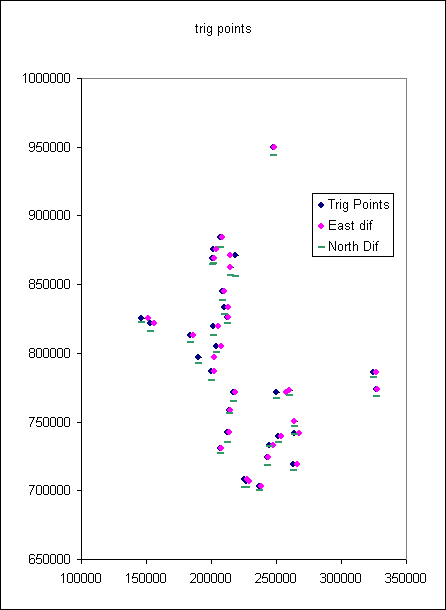
Many summits are graced with a trig point, constructed by the Ordnance Survey to aid surveying (particularly before the days of photogrammetric mapping). For trigonometric mapping to work, the OS need to know the location of key reference points (including trigonometric points) to high accuracy, better than the nearest metre. Thus, if a trig point corresponds to a summit, the OS's own grid reference is probably the most accurate available. However, the OS use a more accurate relationship between WSG84 and the OS grid than is used in hand-held GPS units. The following plot shows the location of trig points on Munros and GPS readings taken at the trig point (blue diamond) showing the deviations of the easting (pink diamond) and northing (green bar). If you enter the OS grid reference of a trig point and navigate to the location, you will find yourself standing (on average, in the Munros area) 4 metres west and 10 metres north of the pillar.
Warning: GPS readings are generally about 10 metres different from precise map locations in Scotland. The data files provide on-the ground GPS readings where available. The trig point readings will be out by about 10 metres, but this is not a real problem; summits only have one trig point (or there would be confusion during surveying) but there may be several knolls competing to be the highest point. This discrepancy should be taken into account when attempting to derive a high-precision grid reference from a map.
But don't be disparaging about this problem. There are a few causes of the discrepancy. a) the Transverse Mercator projection converts the (near-round) globe to a flat plane, a conversion that cannot be perfect and produces some displacements. b) the original grid is based on 19th century triangulation, from a base line in southern England set out using precision-length glass rods and then progressing through the country. That the discrepancy is only about 10 metres is staggering, and a tribute to the old map makers.
Secondly, the OS did not position trig points to mark the summit, but for mapmaking purposes. In particular, the trig point has to be visible from the surrounding land and has to be accessible. The first consideration may apply for the trig points on Slioch and The Saddle, whereas accessibility may apply for Spidean Coire nan Clach on Beinn Eighe. Indeed, it may be the presence of the trig point on Spidean Coire nan Clach that denied Beinn Eighe a second Munro for some years. The trig point at 972 m is lower than Sail Mhor (981 m) whereas the knobbly summit NE of the trig point is now established to be 993 m. The trig point could not be the Munro summit being known to be lower than Sail Mhor, but Sail Mhor could not prevail as long as there was debate whether the land behind the trig point was at least 9 m higher than the trig point. I digress.
A listing of trig point grid references and heights has been posted by Phil Newby on Phil's GPS Waypoint resource pages, which he obtained from the OS and John Davis. Selecting from the 6557 trig points with height over 910 m and Scottish grid references (OS zones NC to NN) provides about 70 trig points (Note: Conival is in a list of main trig points, without a height, but not the full list). Where the trig point is at the summit, this list provides an accurate 10-figure grid reference. Often the trig point is adjacent to the summit cairn, or has been incorporated into a summit shelter, so the grid reference is 'good.' For Slioch and The Saddle, the trig point location is listed in the tables (and Variorum Table) and corresponds to a deleted top. Gulvain's lower S Top has the trig point, sufficiently distinct to have retained Top status. For a number of other Munros, the trig point is known not to be at the summit. I have identified Spidean Coire nan Clach, Beinn a' Ghlo - both Carn nan Gabhar and Carn Liath, Ladhar Bheinn, and Ben Vorlich (Lomond). These 5 have been excluded from the Best Estimate list, whereas the trig points for Slioch and The Saddle are obsolete Tops. Please let me know if you are aware of others. For the Loch Earn Ben Vorlich, the trig point is, I believe, at the summit, whereas the summit cairn (100 m away) is apparently lower (consistent with The Tables).
Before consolidating the data, checks were applied to establish whether the more precise data (from Gerry Bye or from GPS measurements) improved the accuracy compared with the tabulated 6-figure grid references.
Four sets of data have been compared, SMC tables of 1981, as revised in the 1990 revision (SMC 81/90), the SMC tables of 1997 (SMC 97), 389 summit waypoints determined by Gerry Bye (the 284 Munros plus about 105 Tops) and 100 waypoints determined by GPS, using the SMC 1997 tables as the standard. Note also the grid reference ambiguity, whether the grid reference is given as the nearest location of the origin in the square the point is in. See The ambiguity of Grid Reference tables If strictly applied, 6-figure grid references would be converted to 10-figure grid references by adding 50 to both the eastings and northings, i.e. the best estimate of the 10-figure grid reference of Ben Lomond (NN 367 028) would be NN 36750 02850. On the basis of the current analysis with 8 and 10 figure data, the average adjustment for the SMC 81/90 tables is calculated to be 19 and for the SMC 97 tables 42.
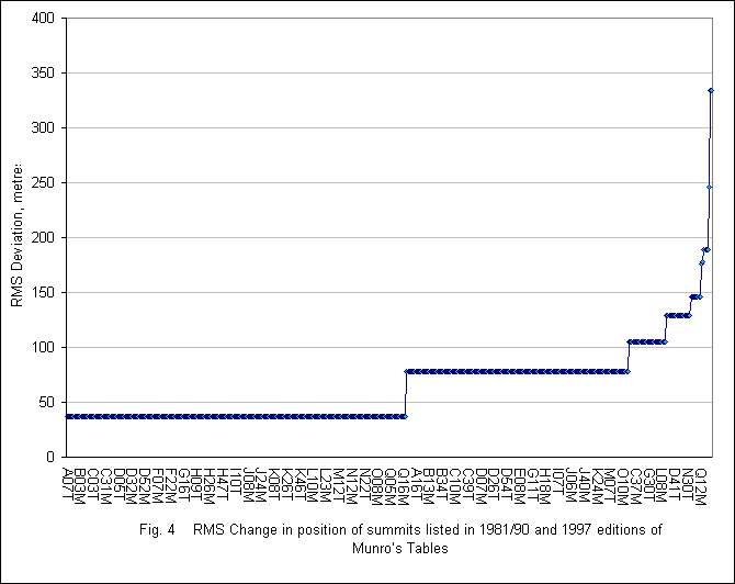
Taking the data sets in pairs, the difference in the grid reference was determined for each summit in both the easterly and northerly directions. The following graphs present these differences as easting and northing differences. The summits are in sequence of the Modern Munro areas, in order of precedence as in the Variorum, using the summit notation of the Variorum with the subscript M for Munro, T for Top and X for deleted Top or Munro (as in the SMC 97 tables).
The first graph shows the changes applied between the SMC 81/90 data and SMC 97. The y-axis gives the discrepancies between the data sets. Most points are on the line are 36.8, corresponding to the same grid reference being quoted, but with different adjustments to generate 10-figure grid references. The next most common result is at 78.4, where the SMC97 figure is 100 m to the SW e.g. Ben Lomond was NN367029 but became NN367028. The two greatest deviations are for Tom na Sroine and Cairn of Gowal (both Tops). If a grid reference is quoted to 6 figures, there is an inherent 100 metre error, however carefully the measurement.
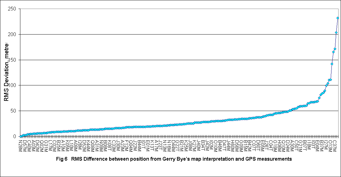
The corresponding plot for Gerry Bye's data is presented in the next graph. Most points fall in the range +/- 50 m corresponding to the range expected moving from 6 to 8-figure grid references. All points are within the range -200 to +150 m.
Notes:
Gridlines are at 25 rather than 100 metre intervals.
The tops are not always specified in the Munros routes from which data were extracted,
and hence some tops may be erroneous. Further checks are required.
BQ07M is Cruach Ardrain, LY02M Meall nan Aighean, EL03M Beinn Eibhinn, TO12M
Spidean Coire nan Clach (probably the trig point, not the summit), SK06M Sgurr
a' Ghreadaidh.
The next graph compares the GPS data that have been obtained (and reported) with the SMC 97 summits. Again, most points are within the +/-50 m range. There is only two deviations over 100m (LA18M Beinn Teallach and LT02M Meall Garbh).
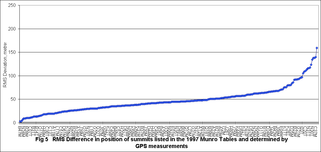
The final graph compares the two higher precision data sets, GPS values and Gerry Bye's data. It will be seen that most points lie in the range +/-30 m, with many in the range +/-10 m. A clear advantage in reducing ambiguity, but with a number of significant deviations. Were the GPS measurements in error, or was there difficulty in interpretation of the map? More (and duplicate) GPS measurements of summits are sought.
BQ03T is is the wandering Beinn a' Chroin West Top, BQ07M Cruach Ardrain, LY02M Meall nan Aighean, LT03M An Stuc, LT02M Meall Garbh, MF10M Sgiath Chuil, SD01M Carn an t-Sagairt Mor, LA18M Beinn Teallach and EL03M Beinn Eibhinn, TO12M Spidean Coire nan Clach (GPS at the summit), GU04M Meall nan Ceapraichean and GU06M Eididh nan Clach Geala
| Code | Name |
| H70T | Beinn a' Bhuird - South Top |
| N17M | Sgurr nan Each |
| D56M | Beinn Eibhinn |
| C37M | Buachaille Etive Mor - Stob Dearg |
| J32X | Gleouraich - Craig Coire na Fiar Bhealaich |
| K15T | A' Chralaig - A' Chioch |
| C04T | Ben Cruachan - Drochaid Ghlas |
| O13M | Eididh nan Clach Geala |
| B11T | Sgiath Chuil - Meall a' Churain |
Analysis of the Munro Tables (81/90 and 97), Gerry Bye's data and GPS data (now almost 200 points) has generated the following table of 'suspect' summits. Prime concern is for summits with SMC97 listed as a source of conflict, assuming 'new' tables are primarily derived from these.
The following Munro trig points are not at a summit.
Others may still be added
Spidean Coire nan Clach, Beinn a' Ghlo - both Carn nan Gabhar and Carn Liath,
Ladhar Bheinn, Ben Vorlich (Lomond) and possibly Carn Gorm (Glen
Lyon). For Slioch and The Saddle, the trig points are at Deleted
Tops.
|
Code |
Name |
Deviation, |
Data Sources
in conflict |
Comments |
|||
|
A06M |
Ben Vorlich (Lomond) |
151 |
|
SMC 80/91 |
GPS |
|
|
|
A16M |
Beinn a’ Chroin |
203 |
SMC 97 |
SMC 80/91 |
GPS |
G. Bye |
The moving Munro – latest map at odds with tables |
|
A20M |
Cruach Ardrain |
153,129 |
|
|
GPS |
G. Bye |
The Variorum cites the SW summit |
|
A27T |
Stob Binnein - Meall na Dige |
192 |
SMC 97 |
SMC 80/91 |
|
|
|
| A28M | Beinn a' Chroin - West Top |
308 |
SMC 97 | SMC 80/91 | GPS | 'New' Munro is Point 4; West Top was Point 3 | |
|
B11T |
Sgiath Chuil - Meall a' Churain |
149, 91 |
SMC 97 |
SMC 80/91 |
GPS |
|
|
|
B19T |
Beinn Mhanach - Beinn a' Chuirn |
177 |
SMC 97 |
SMC 80/91 |
|
|
|
|
B22M |
Meall Garbh |
106 |
SMC 97 |
|
GPS |
|
|
|
B38T |
Carn Mairg - Meall Liath |
175 |
SMC 97 |
SMC 80/91 |
|
|
|
|
B44M |
Carn Gorm (Glen Lyon) |
113 |
SMC 97 |
|
GPS |
|
trig point at opposite end of the summit ridge to
spot height |
| C04T | Ben Cruachan - Drochaid Ghlas | ||||||
|
C24M |
Stob a' Choire Odhair |
192 |
SMC 97 |
SMC 80/91 |
|
|
|
| C37M | Buachaille Etive M, St Dearg |
142 |
SMC 97 |
|
GPS |
G. Bye |
Summit cairn/shelter are ENE of 1022 spot ht |
|
D25M |
Aonach Beag |
85 |
SMC 97 |
|
GPS |
|
|
|
D28T |
Tom na Sroine |
333 |
SMC 97 |
SMC 80/91 |
|
|
typographic error in the 1997 tables? |
|
D55T |
Beinn Eibhinn -Meall Glas Choire |
249,204 |
SMC 97 |
SMC 80/91 |
GPS |
|
comma-shaped 920 m contour, difficult to interpret
from map |
|
D56M |
Beinn Eibhinn |
123 |
SMC 97 |
|
GPS |
|
two 1100 m ring contours |
|
D59T |
Geal-Charn - Sgor Iutharn |
231 |
|
|
GPS |
G. Bye |
|
|
D60T |
Carn Dearg - Diollaid a' Chairn |
136 |
SMC 97 |
|
GPS |
|
|
|
E04M |
Geal-charn (Dromochtar) |
192, 132,179 |
SMC 97 |
SMC 80/91 |
GPS |
Graham Hartley |
two cairns at much the same height.
GPS does not agree with either tables. |
|
G15T |
Cairn of Gowal |
333 |
SMC 97 |
SMC 80/91 |
|
|
Moved to 991 m summit between the (1980) 983 m
summit labelled as Cairn of Gowal and the 1012 m Cairn Bannoch |
|
G21M |
Carn an t-Sagairt Mor |
106 |
SMC 97 |
|
GPS |
|
two cairns 100 metres apart at much the same height |
|
H04T |
Sgor Gaoith - Meall Dubhag |
219,134 |
SMC 97 |
SMC 80/91 |
GPS |
Graham Hartley |
2 equal summits, walker reported |
|
H70T |
Beinn a' Bhuird - S Top |
158 |
SMC 97 |
|
GPS |
|
ill-defined – walker reported what seemed to be
highest point |
|
I02M |
Beinn a' Chaorainn |
95 |
SMC 97 |
|
GPS |
|
|
|
I03T |
Beinn a' Chaorainn - North Top |
98 |
SMC 97 |
|
GPS |
|
|
|
I18M |
Beinn Teallach |
124 |
SMC 97 |
|
GPS |
Alan Shepard |
double summit two rocky outcrops 150 metres apart,
unresolved |
|
I27M |
Carn Sgulain |
161,160,100 |
|
SMC 80/91 |
GPS |
G. Bye |
GPS data from 2 walkers |
| J32X | Gleouraich - Craig Coire na Fiar Bhealaich | GPS | |||||
| K15T | A' Chralaig - A' Chioch | GPS | |||||
|
K37T |
Mullach na Dheiragain - Carn na Con Dhu |
93 |
SMC 97 |
|
GPS |
|
|
|
K49T |
Carn Eige - Stob a' Choire Dhomhain |
192 |
SMC 97 |
SMC 80/91 |
|
|
|
| L23M | Sgurr nan Ceannaichean |
74 |
GPS | Graham Hartley |
double summit 74 metres apart,
unresolved |
||
|
M15M |
Beinn Eighe - Spidean Coire nan Clach |
166 |
|
|
GPS |
G. Bye |
Trig point rather than the summit |
| N16M | Sgurr nan Clach Geala |
53, 83 |
GPS | Discrepancy between trig point and cairn | |||
|
N30T |
Lord Berkeley's Seat |
133 |
SMC 97 |
|
GPS |
|
An Teallach ridge - notoriously difficult ridge to
interpret |
|
N31T |
Corrag Bhuidhe |
116 |
SMC 97 |
|
GPS |
|
An Teallach ridge - notoriously difficult ridge to
interpret |
|
O13M |
Eididh nan Clach Geala |
111 |
|
|
GPS |
G. Bye |
OS map spot height at SE end of summit ring |
|
Q18T |
Bruach na Frithe - Sgurr a' Fionn Choire |
119 |
|
SMC 80/91 |
GPS |
|
|
|
Q24T |
Knight’s Peak |
20 |
|
|
GPS |
Rob Milne |
Double-topped bouldery summit, with two distinct
peaks |
Where the OS trig point figures were compared with Gerry Bye's trig point grid references or a direct GPS measurement, the greatest deviation was about 24 m. (Note: Beinn a' Bheithir - Sgorr Dhearg should be deleted from the OS list as its location was determined from the map, not OS sources - see next update)
The Best Estimate GPS data files (Use <back> on your browser to get back to this page)
Warning: GPS readings are generally about 10 metres different from precise map locations. This is attributable to the simplified interpretation of the OSGB datum used in hand-held GPS units, as compared with the more precise formulae used by the OS. The data files provide on-the ground GPS readings where available. The trig point readings will be out by about 10 metres, but this is not a real problem; summits only have one trig point (or there would be confusion during surveying) but there may be several knolls competing to be the highest point.
For each summit, the grid reference is the first available in the sequence:
OS trig point grid reference (10-figure) where the trig point is believed to correspond to the summit (Munro, Top or deleted Top) Suffix: G (thanks to Phil Newby and John.Davis). 54 summits
GPS reading (if confident about its authenticity) to 10-figures, averaging multiple values.
Suffix: (Numbers approximate)
E for data from Henry Marston 83 summits (+ 9 Corbetts)
S for data supplied by Alan Shepard 23 summits
B for data obtained from Bergleiter 11 summits
H for Graham Hartley 54 summits (+ 1 Corbett)
K for Ken Crocket 8 summits
R for Rob Milne@ 61 summits (+ 86 Corbetts)
M for data supplied by Doug Meiklejohn 2 summits
C for data supplied by Nigel Cliffe 5 summitsfrom Relative Hills of Britain data (Chris Crocker and Graham Jackson) (To date, only Munros have been processed)
X Alex Barbour 3 summits
D David Baird 27 summits
V Graham Jackson 40 summits
I Iain Rudkin 8 summits
J John Barnard 7 summits
L Laurence Rudkin 59 summits2 for duplicate data from a single walker (12 summits)
The average of the following five data sets, as available (approx. 311 summits)
Gerry Bye's figures, derived from the map to 8-figures, i.e. the last figure in the 10-figure Northings and Eastings is zero. Suffix: Y
Update of Gerry Bye's figures (mainly the Munros rather than the Tops)
The SMC 1997 grid reference, expanded to 10 figures by appending the
average figure of 42 to the Northings and Eastings
126 summits
The SMC 1981/90 grid reference, expanded to 10 figures by appending the
average figure of 19 to the Northings and Eastings
7 summits
6-figure Grid References taken from the listing on the Liverpool University hill walking site compiled by Alan Dawson and Brenda Lowndes, expanded to 10 figures by appending the average figure of 40 to the Northings and Eastings
Robin Campbell's Variorum Table (generally the grid reference in the 1974
Tables) expanded to 10 figures by appending 40 to the Northings and Eastings. Suffix:
V
49 summits
10-figure grid references derived from description in
Robin Campbell's Variorum Table and location interpreted from map, see appendix.
15 summits. Some are less than 914 m, others small knolls at the end
of the summit ridge, and in one case below a small rise
The numbers of summits corresponds to the number used in the table, except for supplied GPS data, which gives the number provided by each walker/source.
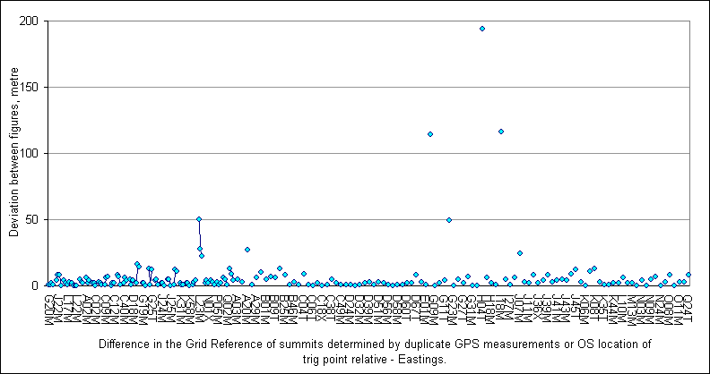
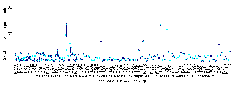
For (i) and (ii), analysis of the duplicate OS trig point data and GPS measurements to date (either trig point and one GPS reading, or two GPS measurements) shows the following data:
| Eastings | Northings | |
| Pairs | 97 | |
| Trebles | 25 | |
| Quadruples | 4 | |
| Av. | -7.09 | 4.68 |
| Std Dev | 41.28 | 33.51 |
| Max | 122 | 85 |
| Min | -209 | -126 |
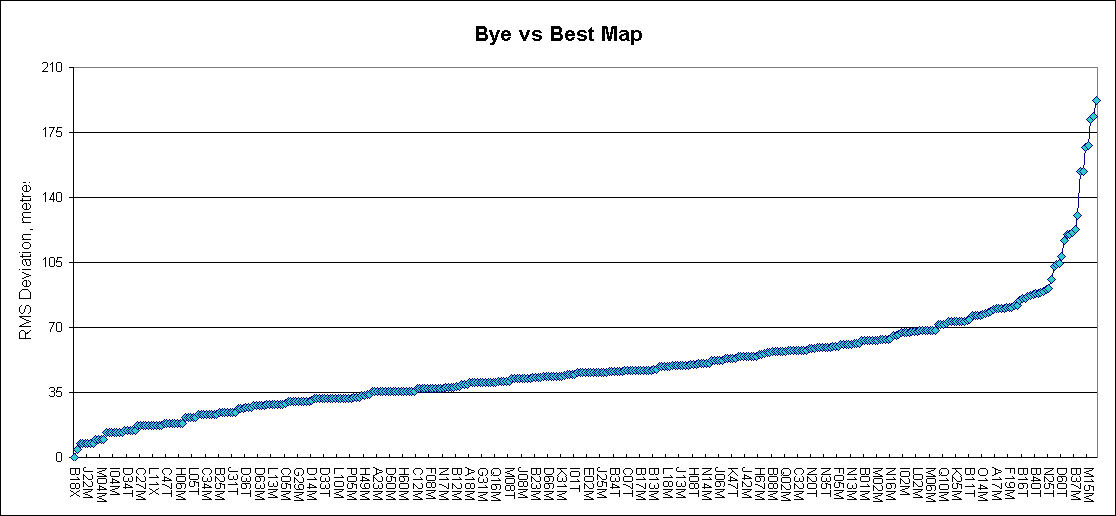
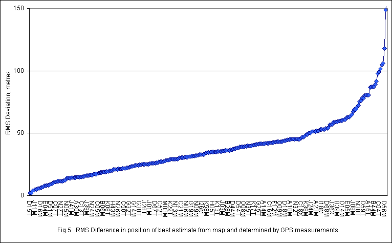
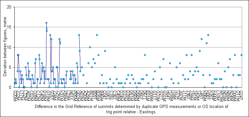
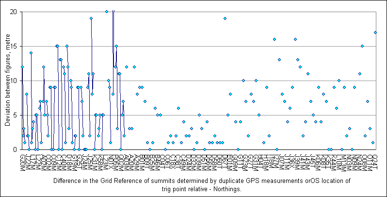
The following graphs compare the trig point and GPS figures with the 'best map' figure, based on the average of available figures as in (iii) above. For each summit, the multiple readings are linked by lines, for respectively the eastings and northings. If the 'best map' figure is a good representation, points should lie within the range ±50 m. As can be seen, this is predominantly the case, i.e. the adjustments to convert 6 figure grid references to 10 figure grid references are generally appropriate. In the majority of cases, the multiple points are almost coincident, i.e. the GPS and trig point data show good reproducibility.
High deviations:
B44M Carn Gorm (Glen Lyon) trig point is at the opposite end of the summit ridge
to spot height. Walker reported trig point - is this another summit where the
trig point is NOT at the highest point; requires confirmation
C37M Buachaille Etive Mor - Stod Dearg The summit cairn/shelter are ENE of
1022 spot ht. Two walkers have instinctively reported the location of the
cairn. Perhaps it should be confirmed that the cairn is at the highest
point - or do we accept that the cairn and shelter are what should be visited?
Inconsistent GPS readings:
E04M Geal-charn (Dromochtar) Two cairns at much the same height, not
resolved by the walker; requires confirmation.
G21M Carn an t-Sagairt Mor Two cairns 100 metres apart at much the same
height, not resolved by two separate walkers; requires confirmation.
H04T Sgor Gaoith - Meall Dubhag 2 equal summits, walker
reported; requires confirmation
I18M Beinn Teallach Double summit two rocky outcrops 150 m
apart, unresolved by walker; requires confirmation
N16M Sgurr nan Clach Geala Discrepancy between trig point and cairn;
requires confirmation.
O13M Eididh nan Clach Geala OS map spot height is at SE end of summit ring
The Munros guide says the NW cairn, where GPS readings were taken by 2 walkers;
consider reconfirmation
Q24T Knight’s Peak Double-topped bouldery summit, with two distinct
peaks only 20 m apart, unresolved by walker; requires confirmation. However,
height may
be below 914.4 m
Most points are close to the axis, with a few severe outliers. The graphs are repeated showing duplicates within 20 metres. For each summit with two readings, a point showing the difference (easting and northing) is plotted. In cases to the right of the plots, one grid reference is for the trig point, the other a GPS reading. On the left there are 3 or 4 determinations. If three, the 3 differences are shown. If 4, 4 of the 6 possible differences are plotted.
Note: the OS maps remain the arbiter of altitude. This corresponds to the last appearance in the tables, as for Beinn an Lochain, 921 m when last listed (1974) but now known to be less than 914 m.
Format of GPS data - the 6 character identification code, 10 digit Grid Reference, truncated name and data point symbol.
Two identification systems have been used (a) the 'RNC' system using the 2-letter - two digit identification in the Variorum Table in Robin N Campbell's "The Munroist's Companion," but with the addition of suffixes M for Munro, T for Top and X for deleted Top or Munro, plus source of GPS data. (b) a derivative of the system (HFM system) I have previously used, based on the modern Munro sectors changing section numbers to letters A to Q, but in each section putting the Munros in precedence order as in the RNC system. Tops and deleted tops normally appear after the relevant Munro. Here the status (M, T or X) is inserted as the second character.
Explanation:
For his Variorum Table, Robin Campbell required a system to consolidate the five
main listings, and to be able to cross reference, taking into consideration the
different groupings and sequences that have been used by different editors. By
identifying 58 mountain groups, compiling the tables was made manageable.
Each group was given a 2-letter code, e.g. AR for the Arrochar Alps, LU for Ben
Lui. In each group, summits are numbered in sequence in order of their
appearance in the Tables. The fifth letter is the status, the sixth the
source.
In my original listings from the 1990 tables (hence my specification of the 81/90 tables), I derived a system in which the Munro sections was given as a letter A to Q for Sections 1 to 17. The sequence number for each summits was then appended, with a leading zero for summits 1 to 9. A 'T' was appended for Tops (nothing for a Munro). Although the 1997 tables used the same sections, the order in the sections was changed, and of course there were some deletions and additions. The system had broken down. The revised system still used the Munro section (as a letter A to Q) for the initial letter. The sequence number in each section (to include Munros, Tops and Deleted Tops) was derived from the sequence numbers used in Robin Campbell's Variorum Table, i.e. based on precedence. The current status (M for Munro, T for Top or X for Deleted Top) is also included as a suffix (fourth character), with the source as the fifth character. The HFM system uses a maximum of 5 characters, the RNC system up to the maximum of 6 characters for GPS waypoint identification on a basic GPS receiver.
I believe it would be useful if future editions of The Tables included a permanent reference identification for each summit. I would also like to see 10-figure grid references, if only to assist in any debate as to which knoll or outcrop of rock has been accorded summit (Top or Munro) status in a complex area, e.g. the west ridge of Beinn a' Chroin, where once the highest point has been identified its height relative to the East Top can be resolved to determine which is the Munro (see Hunt the Munro)!
The description is a name condensed to 16 characters. Apologies in advance for corruption of the Gaelic. Only capital letters and hyphens are available.
The symbol (last element on each line) is 10 (Munro), 15 (Top) or 7 (Deleted) depending on the status. On a Garmin GPS12 these display as a Red Cross cross, a white T in a black circle (backtrack) and a wrecked ship respectively.
The Corbetts
The Corbetts seem to be more regular than the Munros. There are generally only slight discrepancies between 1980/91 data, 1997 data and Blanco's 6-fig grid references. Gerry Bye's 8-fig grid reference data have been added, the 'best estimate from the map' being the average of these four figures. GPS data have been provided by Rob Milne (86), Relative Hills (49) and Henry Marston (5), duplicates being averaged. Trig point data have been identified for 81 summits. For the Corbetts, the overall Best Estimate is the average of (up to) 3 figures, the 'best estimate from the map,' the (averaged) GPS data and the trig point figure for the PCX5 data. The Garmin symbol for a current Corbett is a deer (symbol Nº 13).
For summit identification, I realise I had earlier used Blanco's sub-regions for the Corbetts. Section 1 has sub-sections 1A, 1B, 1C and 1D. If new summits are discovered they can be added to the end of the sub-section rather than the end of the section. Corbett Section 10 only has the Corbetts in Section 10B as listed in the Corbetts tables in The Munros Tables; 10A is Section 18 (R). Blanco's regions extend over the remainder of Scotland and indeed the whole UK and Ireland.
These sub-sections do not coincide with Robin Campbell's, which are essentially for the Munros (his list does not include non-Munro areas). But Blanco's system needs some thought. OK, Section 5 is small enough not to need sub-sections, but all of the numerous Munros in Section 7 are in 7A except Mount Keen (7B) and Section 8 is split W (8A) and E (8B) at Glen Derry, the Lairig Ghru not being used to mark a sub-division.
Significant Corbett deviations
| Code | Name | Deviation metres |
Comment | |
| JB8C | Sgur nan Eugallt | 590 | SMC Corbetts guide says summit is 600 metres NW of trig point; tables give grid ref of trig point | |
| CC3C | Beinn Udlaidh height given as 840 m |
218 | Where is actual summit on plateau? Tables locate spot height, 840 m or a nearby mapped cairn. Same height as the 300×150 plateau contour, with rocky features - one must be higher than the contour! | |
| IB8CX | Corrieyairack Hill | 135 | ||
| RB5C | Carn na Nathrach | 131 | ||
| MA4C | Ruadh-stac Beag | 128 | ||
| PE1C | Quinag-Spidean Coinch | 128 | ||
| RC2C | 2 | Creach Bheinn | 126 | |
| UA3C | Ben Rinnes | 116 | ||
| FB1C | Ben Gulabin | 116 | ||
| RB5C | Carn na Nathrach | 116 | ||
| RB7C | Sg Ghiubhsachain | 115 | ||
| JA4C | 2 | Bn na h-Eaglaise | 109 |
Z1B1C Shalloch on Minnoch: trig point is NOT at highest point but at 'back' of summit plateau.
These waypoint files have now been updated with the trig point data as also the .csv file (see below)
In each set for the alternative identification schemes, the first file gives all 594 summits with waypoint data, s for south those south of the Great Glen (sections 1 to 9) and n for north sections 10 to 17. The 6 PCX5 files have been 'zipped' (together with the .csv version, see later) with a password. E-mail me at henry@NOThmarston.co.uk to request the password (removing NOT, and include a Subject and Body text - unexplained attachments are treated as spam)), primarily provided to people who are involved with the project to determine 10-figure grid references for the Munros and other summits, e.g. by collecting on-the-ground GPS data.
RNC (c) and HFM (h) id system Updated versions added 20 May 2006, now with (over) 380 trig points and GPS readings from over 250 different summits for the Munros, the 140 Corbetts (NOTE: A COUPLE OF CORBETTS WERE (DRAMATICALLY) INCORRECT, BY (e.g. 80 km). THESE HAVE NOW BEEN CORRECTED IN THE CURRENT VERSION OF THE ZIP FILE)
File name ends in:
_map for best from map (as iii above)
_gps for GPS data
_best for trig point data (trig point believed to be at summit) or failing that
GPS or failing that best map (for Corbetts, average of these three figures, as available)
Data
file for reading into a spreadsheet (includes OS trig point data)
This .csv (comma separated variable) file can be used to generate files for GPS for other formats,
for drawing maps (see below), generating your own database or
indeed any other purpose that you can imagine. The
file has been 'zipped' with a password (same password, same archive as the
previously mentioned files). E-mail me to request the password, provided
to people who are involved with the project to collect on-the-ground GPS data
for summits
Format (description of columns)
HFM Code: Summit identification by modern section and precedence number (approx), plus status
RNC Code: Code as in Robin N Campbell's Variorum Table
Top of: RNC Code for parent Munro in latest list (same as RNC Code for a Munro)
Name: Full name
Category History: status over the years, as in Variorum Table (with indication of change in Name, Height, Location)
GPS Name: 16 character name using letters, hyphens and spaces only, for GPS unit
Best: Source of Grid
Reference:
1=GPS 2=SMC97 3=SMC81/90 4=Variorium (old summits) 5=GPS Supplied by other
walker (code in last column) 6=Map reference derived by Gerry Bye. 7 OS trig point.
8 derived from map for obsolete summits
Precedence is 7, 1 and 5 where available, and subject to comparison, 6, 2, 3, 4
Latest category: M, T or X as per 1997 tables
The next 6 columns present the 'Best' 10-figure grid reference, firstly with separate columns for the zone, easting and northing, consolidated to a single field, and then a fully numeric grid reference where, for example, zone NN is expressed as 27, as listed. This format facilitates graph plotting, as otherwise a plot will wrap to the other side of a graph on reaching a zone boundary. For summits that only appear in the first two listings, zero grid references are given, with no code.
The final column gives the
altitude in the latest listing in which the summit appears.
Disclaimer: Whilst every care has been taken in preparing these list, no responsibility can be accepted for any errors or omissions.