Additional data for Obsolete Munros and Tops
These are the obsolete Munros and Tops for which I have derived grid references. Some illustrative maps have been obtained from the Ordnance Survey Get-a-map service. Grid references were obtained from other sources for some summits excluded after the second edition, e.g. waypoints on Gerry Bye's Munro routes.
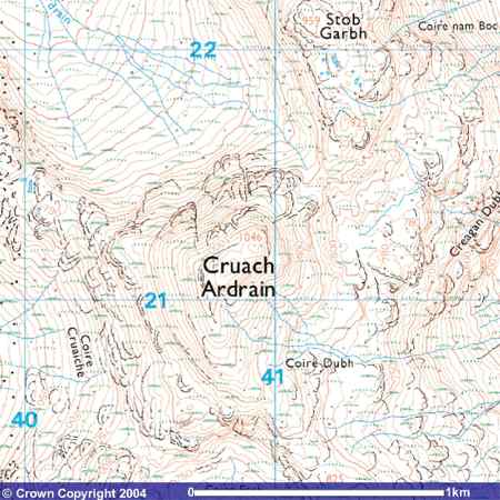
HFM code:A20X RNC code:BQ06 Cruach Ardran, NE top
A case of identification of the highest point on a plateau. Checking the
map, it seems that the 81/90 and 97 tables give the grid reference of the NE top
(NN 40932 21208 spot height 1046) as the Munro. To quote The Munros guide,
" ...the route (from the south) leads first to a flat top with two cairns
about 25 metres apart. To the NE, across a slight dip in the ridge, is the
true summit with a single large cairn." The SW top appears to be at NN 40816 21125
(hidden by name)
A22X BQ08 'between Cruach Ardrain & Stob Garbh' is a small 2-contour
(from Stob Garbh) 925 m
knoll at NN 41270 21720, justifiably deleted!
6-figure grid reference for Get-a-map NN409212
The map images are produced from the Ordnance Survey Get-a-map service. Enter an appropriate 6-figure grid reference, e.g. NN409212, to get a (clearer) 1:25000 map (you can zoom out to 1:50000 and further). Image reproduced with kind permission of Ordnance Survey and Ordnance Survey of Northern Ireland.
A27X BQ13 NN 44747 22392 Creag a' Bhragit is a 3-contour 916 m summit - it may be
below 914 m and is not very prominent
6-figure grid reference for Get-a-map NN447223
B02X MF02 NN 41112 37344 Beinn Heasgarnich - Stob an Fhir Bhogha is a
1-contour ring just the
end of a ridge on the route from Creag Mhor.
6-figure grid reference for Get-a-map NN411373
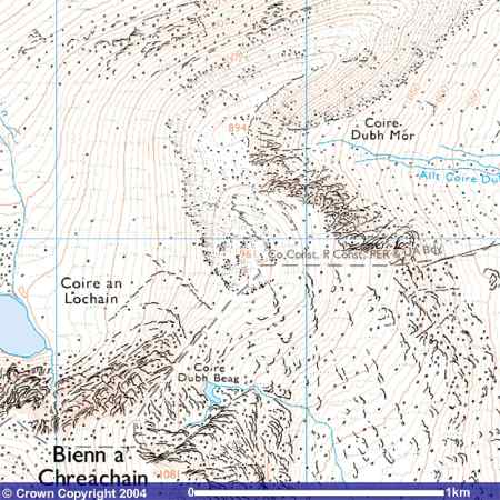
B17M OR06 Beinn a'Chreachain
B18X OR07 Top of Coire Dubh NN 37813 44901 Quoted as 959 m, so taken as
the 2-contour 961 m knoll on the N ridge (rather than the more prominent - but
still only1-contour - 894 m summit).
Justifiably deleted.
6-figure grid reference for Get-a-map NN378449
B28M LT08 Meall Corranaich
B27X LT07 Sron dha-Murchd 927 m Is it the small 1-contour 941 m knoll on the ridge
or the 1-contour 915 m knoll on a spur at the end of the ridge at NN 60934 40385? An
example of Robin Campbell's paradox: a side summit is too close to the Munro,
but a more distant, lower summit (a knoll on the same ridge) was accorded Top
status. Either/both can be
crossed following the ridge along the boundary starting from the prominent
cairn.
6-figure grid reference for Get-a-map NN609403
H03X FE03 Mullach Clach a'Bhlair - Druim nan Bo at NN 87390 92154 This
is a knoll at the end of a ridge with a 918 m spot height, not even 1 contour.
6-figure grid reference for Get-a-map NN873921
H55X EC02 Ben Avon - Big Brae NJ 15898 03216 An identified but
non-prominent 1-contour knoll.
6-figure grid reference for Get-a-map NJ158032
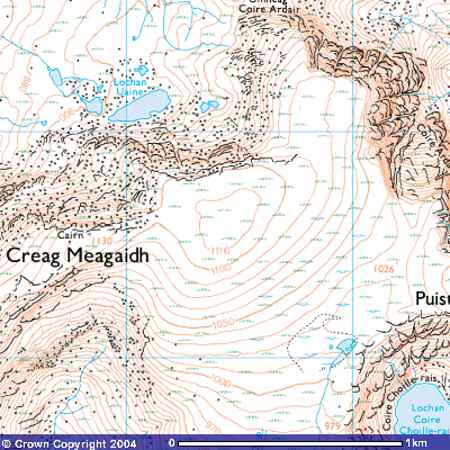
I05X LA05 Creag Meagaidh, E top NN 42807 88125 A ridge with no prominent
knoll. The distance from the main top (0.67 miles, 1.07 km) suggests a location
above the crags, near the northern 'rough ground' symbol, NE of the higher
ground (1110 m contour). If there is rising ground, it is less than 1
contour interval, not my idea of a summit!
6-figure grid reference for Get-a-map NN428881
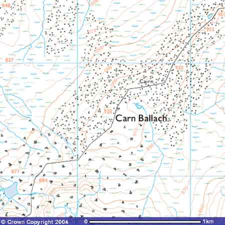
I25X ML06 Carn Ballach, SW Top (now NE top) NH 64853 04989 Carn Ballach
is a flat-topped Top of Carn Dearg. There is a note on this summit at the
end of
Robin Campbell's Valiorum Table. There are two 920 m spot heights,
equidistant from the cairn on the map. The NE top having been deemed to be
the higher by James Gall Inglis(1921), the 81/90 and 97 tables give the grid
reference of the SW top. Accordingly my table gives (as the deleted
top) the grid reference of the NE top.
6-figure grid reference for Get-a-map NH 64853 04989
J19X QO01 Am Bathaich NG 98812 07542 A clearly defined ridge, but
unfortunately too low (910 m according to the SMC Munros Guide, 899 m from spot
heights on the 1:25000 map). There is quite a climb from the intervening
bealach, but apparently not enough to warrant Corbett status.
6-figure grid reference for Get-a-map NG988075
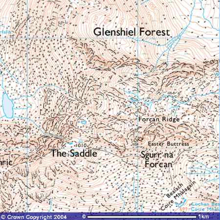
J32X SA06 The Saddle - Sgurr na Creige NG 93567 13722 There
appears to be a 930 m contour ring at the edge of the crags above corrie
labelled Glenshiel Forest, below the G at a bend in the crags.
6-figure grid reference for Get-a-map NG935137
J35X SA07 Faochag NG 95456 12333 A clearly defined, prominent
ridge, but unfortunately too low (909 m). Little climb from the
intervening bealach and does not warrant Corbett status.
6-figure grid reference for Get-a-map NG954123
O02X WY02 Ben Wyvis - An Socach NN 47075 68161 The E ridge from the Munro
summit, Glas Leathad Mor, swings SE and terminates with a 1-contour 1006 m
knoll, on the current 1:25000 map An t-Socach.
6-figure grid reference for Get-a-map NN470681
Some other deleted Munros and Tops. Grid references from
elsewhere
E07X ED03 A'Bhuidheanach Bheag - Meall a'Chaorainn Another example of
RNC's paradox: a side summit is too close to the Munro, but a more distant,
lower summit (a knoll on the same ridge) was accorded Top status.
NN646777
From Blanco's list on Liverpool Univ. web site (in the past):
Sail Chaorainn - South-east Top and Sail Chaorainn
The location of ES08 (K18M) has been listed as the Munro in all 5 editions, but
named Tigh Mor SSW Top, Tigh Mor na Seile SSW Top (1921) and now Sail Chaorainn.
In early lists, Sail Chaorainn is listed as a top, now a deleted top, viz ES09
(K19X) with a similar grid reference to Sail Chaorainn SE Top (K20X) given by
Blanco. From the 1:25000 map:
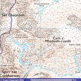
Review: Sail Chaorainn (ES08, K18M) is the Munro, and the 922 m
SE top at NH 14022 14742 is now named Carn a' Mhadaidn-ruaidh on the map,
reference ES09 K19X, now entered in table. This ridge seems to have some
merit (at least in comparison to other deleted tops) and may be reinstated in
future tables, warranting including it in a walk. K20X has been deleted as a
duplicate.
6-figure grid reference for Get-a-mapNH140147
For AF21, K48T Carn Eige - Stob a'Choire Dhomhain NH131264, spot height 1147, an 1143 E top has been identified in Blanco's lists at NH134265. The 1:25000 map is not very helpful as the name Stob a'Choire Dhomhain obscures the terrain at the top of the corrie.
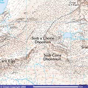
On the 1:50000 map,
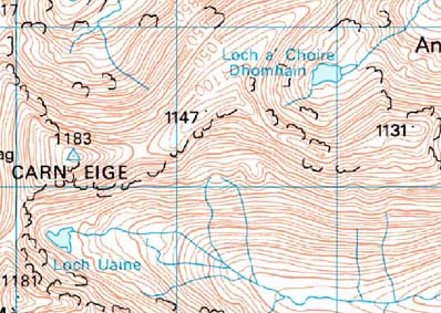
The spot heights from W to E correspond to Carn Eige (1183) Carn Eige - Stob a'Choire Dhomhain (1147) and Carn Eige - Stob Coire Dhomhnuill (1131). The E top of Carn Eige - Stob a'Choire Dhomhain does not seem to be distinct, although it could reward inspection on the ground. As contour lines are not crossed between Stob a'Choire Dhomhain and the E top, only the higher (believed to be at the 1147 spot height) seems to warrant inclusion. Nevertheless, both are included in the lists, but the precise location of the E top (new RNC code AF33, K49X) cannot be discerned from the map better than the quoted NH134265. The summit to the south of the corrie at about NH138262 seems to be about 1130 m.
Disclaimer: Whilst every care has been taken in preparing these list, no responsibility can be accepted for any errors or omissions.