GPS data for Munro and Munro Tops
Help, please!
Appeal for help: If you use GPS when hillwalking in
Scotland, you may be able to help me to build up a database of
Munro and Top waypoint GPS data and key waypoints on routes.
Current GPS lists in
Garmin PCX5 format (view in Notepad to see the grid reference
data)
Acknowledgements ....
Use <back> on
your browser to get back to this page
GPS
data only
GPS
data plus data from SMC Tables 1997
Keep reading...
Why GPS?
Scotland has magnificent but
potentially dangerous country, and GPS can be a valuable aid to
map reading under adverse conditions.
Unsure about using GPS -
See write-up
HELP
PLEASE
Can you please assist in helping
to make a new catalogue of the Munros, listing the location of
each Munro by on-the-ground measurements, using GPS measurements.
I would also like to include the location of Tops and deleted
summits (as listed in Robin Campbell's Variorum in his Munroist's
Companion), Corbetts, Grahams, Donalds and Other hills included
in SMC lists (collectively referred to as summits). I am also
interested in routes - but which hills have a unique, standard
route? Nevertheless, there is often a 'key' point on a route,
a footbridge, col, sorry bealach, path junction, access point
to ridge or more importantly the start of a safe route down. I
do not want to generate routes that can be followed 'blind', without
reference to a map, but rather to provide safety information as
back up. When GPS is used as an aid to navigation it can be a
valuable aid to safety by answering the question "exactly
where am I?"
Why a new list; surely the
SMC Munro tables represent a definitive list? And there are other
lists if that isn't enough.
One problem is that current
lists are derived from maps, not from the ground. The location
of the summit cairn has to be deduced from close reading of a
map. Certainly the current maps derived by photogrametry are very
precise, but are still an interpretation of the ground from an
air photograph.
The second problem is that
the 6-figure grid references traditionally given for the location
of summits is in some cases too imprecise to identify the point
in question. At best, the location is specified to 100 m in the
east-west and north-south directions. Different interpretation
(see later) of the grid reference can increase
this uncertainty to 150 m, even for a well defined summit with
a trig point or mapped cairn.
In many cases, the 6-figure
grid references is sufficient to define the summit that is intended.
However, there is a case where two listed summits have the same
grid reference (Bhasteir Tooth and Sgurr a' Fionn Choire, tops
of different Munros, in the SMC tables of 1997), plus many cases
where there are several knolls and peaks in a grid square so that
it is ambiguous as to which high point is the one intended by
the keeper of the tables. By way of example, the west top of Beinn
a' Chroin is a delightful broad ridge, 200 m × 1000 m, abounding
with lochans and rocky knolls. Delightful, unless you are intent
on finding the highest point, as there are several cairns, but
none at the highest point. This ridge is listed as the West Top
of Beinn a' Chroin, but there is some evidence that the highest
point is actually higher than the east top, the Munro, so it is
quite significant (a) to identify the highest point and (b) to
give a more precise location than is possible with a 6-figure
grid reference, to enable walkers to locate the spot even in conditions
of poor visibility. Robin Campbell has reported that he has had
difficulty in identifying what top the cataloguer had in mind
to list in "confusing places like the Saddle, the An Teallach
ridge, or the awful Mullach na Dhearagain ridge with many small
tops."
With care, it is possible to
derive 8-figure grid references from maps, particularly the 1:25
000 OS maps or 1:40 000 Harveys maps. An 8-figure grid reference
locates the summit to a 10×10 m square, accurate enough
for most purposes, if the summit in question can be identified
on the map. However, for both Slioch and The Saddle the summit
is allocated to slightly higher ground, identifiable on the ground
but inspection of the map does not allow the ring contour with
the higher centre to be identified unabmiguously without having
visited the site.
GPS units work with 10-figure
grid references, precise to 1 m, and probably reproducible to
about 5 m with current hand-held equipment. Such precision should
remove any ambiguity as to which rock has been identified as the
summit. The problem is to get hold of GPS readings for all of
the summits. Ideally, multiple readings taken by different walkers
on different days should be combined, eliminating dubious readings
and averaging the others. I am therefore appealing to walkers
to make a point of recording the location of summits that you
visit. Mark the summit as a waypoint on your GPS unit and pass
the relevant data on to me, please. The procedure required to
get consistent data is summarised as follows:
There are two distinct data
sets I propose: (a) Munros and Tops to 5m (rather than the 100
m of standard OS grid references) (plus Corbetts, Grahams and
Donalds) and (b) key waypoints on the route up and (probably more
important) the safety route down. I was particularly taken by
the fact that altitude readings actually have a meaning.
Munros and Tops:
At the summit, get a time averaged reading of the summit location,
with altitude which may have to be recorded manually (now altitude
readings are consistent, but is there an inherent displacement?).
Put the GPS on the summit cairn, mark the point averaging the
data for a few minutes, until the FOM (Figure of Merit) has dropped
to less than 5 m. The FOM figure and the altitude given by the
GPS should be recorded as well as the name of the Munro/Top. If the summit
has a trig point, please note whether it coincides with the summit cairn, and if
different record the location of both. For a number of other Munros, the
trig point is known not to be at the summit. I have identified Spidean Coire nan
Clach, Beinn a'Ghlo - both Carn nan Gabhar and Carn Liath, Ladhar Bheinn, Slioch,
The Saddle and Ben Vorlich (Lomond). For the Loch Earn Ben Vorlich, the
trig point is, I believe, at the summit, whereas the summit cairn (100 m
away) is apparently lower.
GPS waypoints for deleted Munros
and Tops, Corbetts, Grahams and Donalds also accepted!
Routes:
GPS data on routes should be seen as back-up to navigation with
a map and not a substitute. The first priority is to provide data
to lead walkers to a safe route from the summit, i.e. the route
to the top of the descent(s) from the summit plateau. It is also
useful to identify where the summit path leaves the valley path,
often identified by a (missable) cairn. Typically, routes would
give the car park (or the point the route leave the public road)
so that I can see where you are starting from, with key junctions,
the top of the main ascent to the summit plateau, the summit itself
(with time averaged GPS data as above) plus tops and the point
the route leaves the summit plateau. The data should allow forward
and reverse routes (hence the point at the top of the ascent for
straight up and down outings rather than traverses of the mountain).
These should be specified as waypoints, not just points on routes
(which give truncated waypoint data) or tracking data (difficult
to identify key points, but useful for checking the distance walked
- and interesting if you select a fixed time interval of, say,
4 min, when you look at a graph plot). A written description would
be useful.
Please e-mail me, Henry Marston,
with attached text files of waypoint
and routes and relevant information (background to route e.g.
as described in SMC Munros book, altitude of summits as recorded
by GPS if not included in downloaded data file), GPS unit (e.g.
Garmin 12), and download software package (e.g. PCX5). Make sure
you have set Ordnance Survey GB as the map datum and the British
OS Grid as the Grid option.
The plan is initially to issue
these Munro/Top data (averaged between contributions) and the
routes on links from this web page. Currently I have about 250
summits, some supplied by other walkers, in a waypoint file
Please send contributions to Henry Marston
(given in plain text in case links
above fail - and include a Subject and Body text - unexplained
attachments are treated as spam).
Link to GPS
waypoint download area
The ambiguity of Grid Reference
tables.
Consider a summit with a 6-figure grid reference quoted as
NN 244 456, and assume you have a very large scale map so that
you can impose a detailed grid. Within the 100 km grid square
NN, you identify the matrix point at an Easting or 244 and a Northing
of 456, the centre of the pale blue square in the accompanying
diagram. (Note: this diagram is fictitious, and does not correlate
with anywhere on the Black Mount) Around this intersection there
are four summits, marked as solid dots. Following the instructions
with 1:50 000 maps, estimating tenths eastwards and northwards
implies that summits are given the grid reference of the nearest
matrix point, that is the three dot summits in the pale blue square
would be given the grid reference NN 244 456.
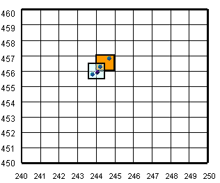
However, one logical aspect of the grid system is that as the
grid reference of a point is increased in precision, the part
already identified remains intact. Thus the square drawn appears
in the 10 km grid square (2-figure grid reference) NN 24. The
4-figure grid reference NN 2445 includes all points in this square
from NN 240 450 to NN 249 459. Extending this principle to 6-figure
grid references, only the two summits in the orange square should
be given the grid reference NN 244 456, one at about NN 2442 4563,
the other at about NN 2447 4568. The dot adjacent to but southeast
of the matrix intersection at NN 244 456 should strictly be listed
as NN 244 455, or NN 2441 4559 at higher precision. But what keeper
of the tables would not list it as NN 244 456?
Where does this leave the user of the tables? Unfortunately
different editors seem to have taken different approaches, increasing
the ambiguity of the 6-figure grid references. Unless you know
the criterion used by the particular editor of tables, a traditional
6-figure grid reference implies at best an uncertainty of 150
m east-west and north-south, or by Pythagoras a range of 225 m,
even with a well-defined summit. For an unidentified contour summit,
the uncertainty can be even greater.
If the keeper of the tables worked on the basis of the light
blue square, i.e. the grid reference corresponds to the nearest
measurement, averaging summit locations would require addition
of 00 to convert 6-figure grid references to 10-figure grid references,
i.e. eee00 nnn00 would take you to the centre of the most probable
square for the summit; it should be within 50 m in any grid direction
(eee is the 6-figure grid reference easting, nnn the northing).
However, if the keeper of the tables used the orange square criterion,
the best derived 10-figure grid references, would be eee50 nnn50.
On the basis of 52 summit locations I have checked GPS, I estimate
the best conversion to 10- figure grid references involves adding
19 to 6- figure grid references for the 1981/1990 SMC tables (eee19
nnn19) and 42 m for the 1997 tables (eee42 nnn42). This suggests
that the earlier tables were based on a 'nearest point' system
(but with summits on the boundary being assigned to the SW-wards
matrix point) whereas the later tables were based on the (orange)
grid square, unless just over the southern or western boundary.
Nevertheless, there are some significant discrepancies, and several
summits have moved by 200 m to 300 m, plus height changes of almost
30 m.
Note:
OSTN02
The grid transformations used in GPS Utility is based on the standard Transverse Mercator projection. This agrees with the transformation produced by most GPS receivers. However, this is not the same as the OSTN02 grid transformation defined by the UK Ordnance Survey. The difference in grid positions can be up to 15 metres and is most noticeable in north Scotland.
The OSTN02 grid is defined by a particular set of distortions of the Terrestrial Frame of Reference (TRF). This is incorporated into an "OSTN02 definitive transformation". For more details see the website http://www.gps.gov.uk/ and the page http://www.gps.gov.uk/guide6.asp.
If you wish to improve the accuracy of your coordinates by utilising OSTN02, then you can do this over a local area by using a corrected BNG grid definition. The file 'ostn02grids.txt contains a number of corrected grids. These offer 1 or 2 metre accuracy over a 100km square. This is achieved by correcting the False Easting and False Northing of the standard grid.
It appears expedient to use the imprecise standard transformation generally
provided by GPS receivers, which will be used in the field.
Back to Help
Contact me: Henry Marston
Back to Henry's Munro/GPS Page
Back to Henry's
Home Page
Updated
19 October, 2011