There has been some discussion on the Munros page of the Scottish Mountaineering Club web site about the correct location of the summit of Beinn a' Chroin. This page looks at this and other similar issues.
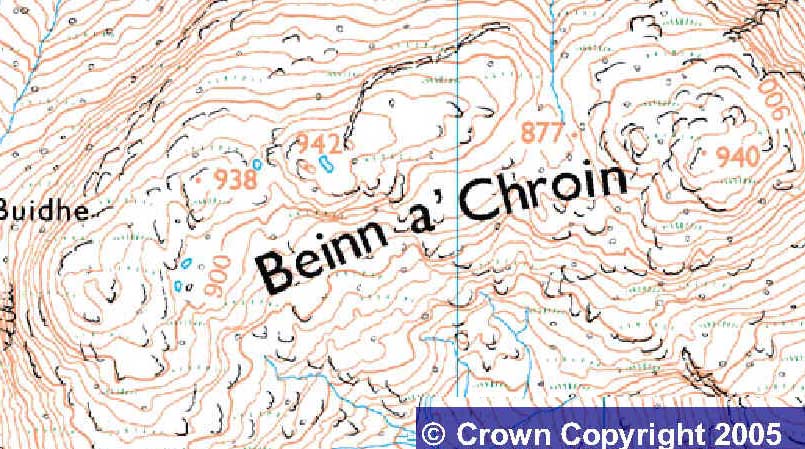
Beinn a' Chroin 941.5m (O.S. 50/56 388 186) M233 is the companion mountain to An Caisteal, in Section 1 of The Munros. It lies above the headwaters of the River Falloch, 6km south of Crianlarich. Two keen walkers became suspicious of the heights as given for the various bumps on the switchback summit ridge of Beinn a' Chroin. Charles Everett pestered the OS and following the usual long and desperate course of correspondence, they were persuaded to resurvey the hill using their stock of aerial photographs.
Richard Webb, Charlie's companion, says he was aware of the error back in the days before 2nd series mapping. In 1983 he did the hill armed with a 1:25000 map which clearly showed a ring contour on the west top at 940m. This trumped the spot height on the other (E) top. Since that map was published, Richard has been in no doubt as to this being the summit. But, he says, interested was only raised after the 1997 revision, due (he says) to Charlie pestering the OS to find out what the missing number between the ring was.
The OS found that the cairn at the east end of the summit ridge (940m), is in fact slightly lower than one of the cairns at the west end of the ridge, the cairn being the fairly large one above a small crag, and with a new height of about 941.5m, making it the new summit. This is given as the Munro on the (updated version of the) SMC Munros CD.
So (using 8-figure grid references,
the minimum appropriate to such discussions - the 100 m range
inherent in 6 figure grid references precludes precise location.
There is a scientific principle of using one significant digit
more than you require)
The 'true' summit is at NN 3880 1856 at 941.5 m Beinn a' Chroin
guessing where the 'new' summit is on a contour ring
The listed West Top at NN 3858 1854 and 938 m is a west bump on
the longer part of the summit ridge, but lower than the highest
point on that part of the ridge so not warranting any status - re-ascent merely 10-20 m.
What was believed to be the summit at NN 3941 1858 and 940 m may
become the East Top. Whether it justifies such status is debatable
involving about 60 m re-ascent from the main summit ridge, although
at the top of a ridge rising from the valley floor.
| Point No |
|
|
|
|
||||
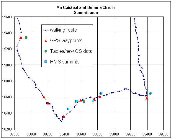
| An Caisteal | 37876 19342 | 1011 | 379 193 | 995 | 3786 1938 | 995 | ||
| 1 | 38393 18355 | 946 | ||||||
| 2 | 384 184 | 938 | ||||||
| 3 | 38598 18560 | 948 | 385 185 | 938 | 385 185 | 938 | 3858 1854 | 938 |
| 4 | 38760 18570 | 954 | 387 185 | 942 | ||||
| 5 | 38830 18605 | 953 | 388 186 | 941.5 | 388 186 | 941 | 3880 1856 | 941.5 |
| 6 | 39399 18587 | 948 | 394 186 | 940 | 394 186 | 940 | 3941 1858 | 940 |
Data taken from Harveys 1:25000 map of Crianlarich for five spot heights, reported by Alan Dawson
Red triangles are GPS measures points (anticlockwise) for An Caisteal, foot of ridge, loachan at bealach, Points 1, 3, 4, 5 and 6 (official Munro of Beinn a' Chroin) with 10 figure grid references. Green circles are SMC and Liverpool data and Blue squares are HMS points with 6 figure grid references. (Visit of August 2000)
View from An Caisteal southern ridge, when the mist had cleared at the 940 m contour (as best as I could). Numbering as in table above:
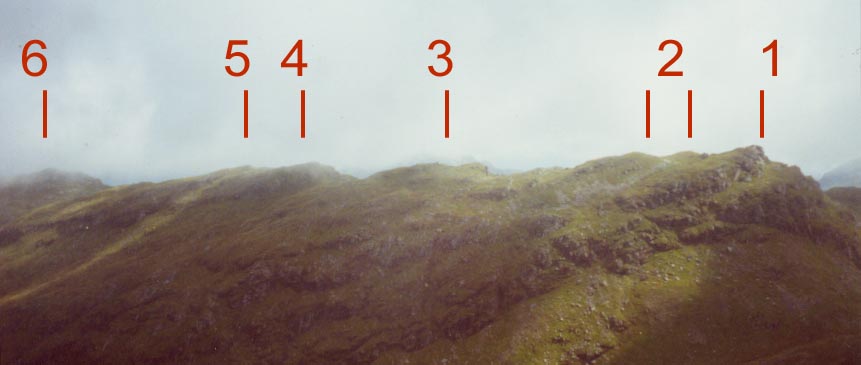
From Westmost summit, Point Number 1 (which seemed to be lower than others):
IF the camera was level, this picture suggests that Points 2 and 3 are lowest (or at least lower than Point 1, the view point), and probably Point 6 (the Munro in the 1997 tables) the highest. More pictures to follow when processed, from other summits. I think I can spot the cairn at Point 3, the Western top listed in The Tables, although as I recall there were several cairns just below higher outcrops.... Points 4 and 5 certainly seem to be the official Western top, and possibly higher than the 1997 Munro.....
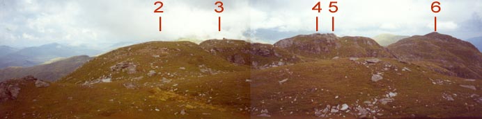
Update: picture taken in May 2002 from the east, on the Beinn Tulaichean - Cruach Ardain ridge at 940 m (according to my GPS). Summit 6 (the traditional summit) is on the left, contenders 4 and 5 near the middle of the picture.
From Charles Everett:
"This is fascinating stuff
and of course makes the plot deepen. The OS
frustratingly still never gave me a figure for the second of those
940
contour rings the one within square 387185 but gave 941.5 for the
one 80m. to
the NE. Now Harveys give the mystery ring 942m and the other one
941m.
i.e. one the OS have said is 941.5 and will be shown on future
maps as 942m.
I expect you saw the update in the March TGO following a press
release from
the OS in which they called me Chris Everett of York. It's amazing
the
number of times people have called me Chris instead of Charles.
It's almost
as if they remember my name begins with C and Chris is the most
common one
that come to mind. Anyway this really puts the cat among the pigeons.
I've
still not been up Beinn a' Chroin and was waiting till such time
as I could go
up there with others plus a tripod and surveyors level so that
I could check
out the height of the unconfirmed SW contour ring. Sounds like
I need to get
on to Harveys and ask them how they determined this figure. I
would assume
it was from photogrametric plotting i.e. the two pictures to create
a 3D image.
I also need to get back to the OS. They really would have egg
on their face
if the SW ring that they never bothered to give me a figure on
turned out to
be half a metre higher than the NE one and hence have the absolute
summit
shifting again."
This case is significant because it seems that the OS are saying the Munro itself needs to be changed; I guess that for the present the munroist should visit at least Points 4, 5 and 6, until the debate is resolved, to avoid the potential need for a return visit later. In particular, if you climb from Inverlochlarig, don't stop at the first (east) summit but go onto the main west ridge. However, as a walker I would say that a return visit would be a pleasure as the top of the west ridge of Beinn a' Chroin is fascinating, abounding with knolls and lochans - go and have a look.
Addendum
I possibly expected a response from someone who had visited Beinn
a'Chroin with a theodolite, but instead was advised of my poor
syntax, that I should write Beinn a' Chroin - an unexpected (but
no less interesting) development. Thanks to Iain R White with
the ISYS
hillwalking website
Addendum 2
January 2005
I checked the current version of the OS 1:25000 map and find:
The map images are produced from the Ordnance Survey Get-a-map
service.
The 6-figure grid reference used for Get-a-map was NN385185 (picture
subsequently cropped)
The OS are giving the summit as 942 m on the Western ridge (my 4, NN 38746 18570 from the map), with the traditional summit at 940 m. That, of course is still the official summit, until the next edition of The Tables, but unless you are close to compleation, I would recommend that you visit both sites. The (now East Top) is, I would say, sufficiently distinct to be classed as a Top. It is the summit of a N-S ridge separate from the (now) main E-W ridge. From the east, cross the bealach, and continue uphill. The 942 summit is on the western end of the first area of rising ground.
Beinn Achaladair
There is a cairn at NN 34609 43347 from which you seem to go uphill before crossing a shallow bealach to another cairn at NN 34346 43114. Tables give the summit as NN 344 432, but under conditions of deteriorating visibility I didn't spot an intermediate cairn.
Summit area of Beinn Achaladair
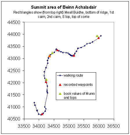
Richard Webb says about Achaladair...
"Never though there was a problem with this until doing the
hill last year", see his
pictures
"The top is clearly marked on the
1:25000 map, yet everyone was ignoring it. Only two sets of prints
amongst the masses of prints went to the summit. All prefered
the 2m lower big cairn."
An Teallach
Apparently the pinnacled ridge from Bidein a' Ghlas Thuill has never been fully documented - maybe a contribution about that will be forthcoming...
Data is provided for private use only; please contact me Henry Marston if you wish to use the data for commercial purposes; there may be copyright implications for the original data.