Rotherham Harriers
and Athletics Club
Trail Running
Section
Rowbotham's Round
Rotherham
through the South Yorkshire
Forest
(The area designated as The
South Yorkshire Forest is mainly rural land rather than a vast
area of woodland)
Use back to
return to this page if there is no link to RRR page
In some cases, you may prefer to right click on links to files and Save
Target As....
email links on this page need an obvious edit to make it
more difficult for scammers to obtain the email address and send spam.
Please send general enquiries to
general enquiries
and specific questions about the web page to
web page
queries
,
making the obvious substitution.
Administrative Changes and Changes
to Route
This section is for
returnees who are familiar with what happened in previous years.
Maps and descriptions
(subject to availability)
are issued at registration on the day;
these are updated up to a week or so before the event for the current year,
although there are sometimes late changes advised verbally.
Printed summaries of the changes will be available for collection on the day at
Registration (after SIcard collection), subject to availability.
There may
be more changes; check here again nearer the day
Changes marked # have been incorporated into
written description, $ into
Wainwright map, @ into
GPS files
Location identifications are common for these 3 navigation modes: A is stage 1,
B Stage 2 etc, followed by a number to show which point (e.g. A1, A2, A4 - not
necessarily consecutive but always increasing)
Changes for 2024
Two stalwarts of the RRRRR
Organising Team have stepped down from their roles.
RHAC club secretary Ralph Rowbotham devised the route during the steel
strike in 1980. Brian Harney
(then Pennine Way record holder) was enticed and organised a number of recce
runs to get familiarised with the route, usually at night. I often joined
in, and well remember an occasion of when one of our group felt tired,
decided to doss down in the garage of someone he knew only to be rudely
awakened by teh police as he'd set off an alarm. The idea emerged, we
should do the route as a race. The congestion of the events
calendar (even then) made us pick the Christmas to New Year gap for the
first race. Seven stalwarts lined up on the day, Barrie Bedford (of
Barnsley),
Brian Harney, Dave Carratt, Henry Marston,
Ian O'Mara, John Abbott
and
Maurice Cooke (of RHAC), supported by family
members. We started at 8 am and all finished by 5 pm. We were
fit in those days! Over the years, numbers slowly increased, with the
first lady participating in 1986 (Caroline Boyd of Maltby). Numbers
progressively increased as the event was given greater publicity. Brian wsa
a regular participant in LDWA events, and posited that the event should be
opened to walkers, on a reciprocal basis. Assuming that walkers would be a
lot slower than runners, their start time in 1990 was set at midnight.
By 1993, it was clear that many walkers were finishing well before dark, so
the midnight
start was changed to
6 am. Over recent years, Brian has been travelling sweeper, using nous
(aided by timing information) to work out when all participants have got
through checkpoints, if they needed to retire or if missing where they might
be.
The youngster in the organising team is
Sharon Burton, coming from the
regular training pool of Rotherham Harriers before picking up the RRRRR
challenge in 1990 and completing 3 times before committing to helping to
organise the event, being official organiser until retiring after this
year's event. Her steady hand on the tiller has helped RRRRR to
develop. Both Sharon and Brian have ambitions to participate next
year, so you'll probably meet them on the route rather than in official
positions.
Now, the RRRRR will continue under the guiding lights of
Stephen Rowbotham (son of Ralph) and his wife Mary. While I am still
able, I plan to continue to run this website, which involves getting hold of
relevant information to post. So, we can look forwards to many Round
Rotherhams in the future. Enjoy! (if that's the right word)
(Note: RRRRR is Ralph Rowbotham's Round Rotherham Route (or
Run, but we don't like to exclude walkers)
Event monitoring: There
will be a different entry procedure and timing system for 2024.
Entries will be taken on Fabian4, with timing and race monitoring using the
Racetek system, operated on the
day by
Fabian4.
On the day, collect a wristband from the Fabian4 desk (on a lanyard for the
relay).
At the Start (when you are ready to set off), at each checkpoint and at the
Finish you present the wristband to a Racetek box, much as you would present a
contactless credit card to a card reader.
The Racetek box then reports your position to 'base' where live positional
results will be on display and the web.
More information on the Entries page
Route Changes: None identified at present -
keep us informed of any problems/changes you encounter on the route
Changes for 2023
There is no through road for vehicles to
Checkpoint 3 at Harthill from Kiveton Park for relay team runners and other
supporters.
Alternative places for supporters to
meet participants are Norwood, at the exit from Rother Valley Park, or
Netherthorpe Airfield. For details see
RouteRoundCheckpoints
Route Changes:
#$@ Stage 2 from B18 to B22
We can save 400 m and revert to (essentially) the old route from Europa Way
to Catcliffe. Fences have been taken down, and the path is 'officially' open
- a signed ROW route through the warehouse complex.
#$@ Stage 5 from E3 towards E6
A farm track from Woodsetts shops leads to a line of trees (hedge).
Traditionally we have taken the field path in front of the hedge/line of trees.
The bridge over the stream has gone and has been blocked off . Instead continue 40
m on the track
round the trees
(past the 'Private' gate), right on the (signed) Bridle Path (at a concrete
block) between a hedge (on the
left) and a fence
to a bridge, leading to the tracks across fields.
You are then back on route.
The GPS files, strip map and written description have been updated: Check you
have the version "Updated 25/09/2023" (or later).
For the GPS files, something went wrong with the update for the late
modification at the start of Stage 5. Some GPS files for the full route and the
one for Stage 5 created on 26th Sept were affected. If you downloaded GPS files
between the 26th and 29th Sept, check whether there is a newer version.
Stage 8 from H8 to H9
For Recce Runs/outings, on weekdays, I am told the canal towpath is closed for
maintenance. If the path is closed, barriered off, follow the signed diversion. Cross the canal on the
sweeping white bridge, continue up the end of the lane at a T junction.
Turn left and follow it to the junction with the dual carriageway. Take the slip
road (now closed to traffic)
up and go down steps to the left, to a
footway by the dual carriageway. Take the next left to the station. At the
station building, go left into the car park and resume the standard route by
going under the railway through a tunnel.
The towpath has been open at weekends and we have been assured that the work on
the towpath
will be open on the day of the event.
Changes for 2022
Organisational
The 2022 event is planned for 1st October, Individual and Relay.
General features of the start procedure from 2021 will be retained, but
with Covid precautions lifted
(if you are not infected).
Individual starts will be from 4 am to 7 am, on a rolling basis as in 2021.
More details of organisation
Route Changes:
Stage 2 from B18 to B22
The open land between Europa Link/Britannia Way (the
road to the Mercure Hotel) and Parkway is being developed to make 4
warehouses and is currently fenced off.
Until access is restored, the alternative route is to cross Europa
Link to the footpath on the north side (best at the bus stop before
B18, the Britannia Way roundabout, or just after), follow this,
crossing the exit ramp from Parkway, through the pedestrian
underpass, past 2 more roundabouts (the second with traffic lights) on the B6533 Poplar Way to the
(new) traffic lights where you can rejoin the original route at B22.
Longer, less interesting but safe. Keep to the footpath on the
right hand side of the road (see next change).
Eventually, an access road between the 2 biggest units will start
where we start across the (formerly) open land and in due course
will link (at 19) to the footpath parallel to Parkway through the
hedge/fence.
Access will not be restored before 1st October
so we will be using the diversion - see
Changes for the diversion on an
expanded strip map.
Modified GPS route files are available from the
SatNav/GPS file page. Maps,
written description, etc on the navigation
page
Next year
we will revert to the original route (albeit
modified) -
Stage 2 from B22 to B23
However you get to B22, ignore the fisherman's path
and signed footpath. Instead, from Poplar Way, take the
crossing at the right hand traffic lights and go straight ahead up
the wide bricked track towards houses at the edge of the estate. At
the top, jink left onto the broad rick-red track along the edge of
the development. Follow this track to the grey-green ridge (B23)
(From Catcliffe, continue to the traffic lights at the Waverley
Estate side of the junction and go left.)
GPS files have been modified to incorporate the
B18-B22 changes (approximately) for when the path is re-opened. If
you see an open gate to the site, don't attempt to go that way - you
won't get out at the under-bridge. The change at B22 has been
incorporated into the GPS files.
Changes for 2021
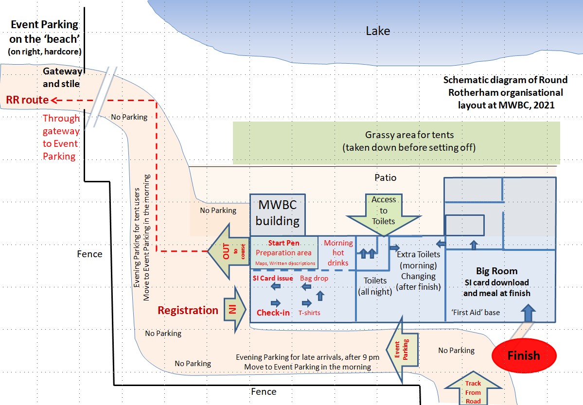
(see below MWBC site plan for route changes)
Organisational
The 2021 event is planned
for 9th October, Individual and Relay. The required permits have been received,
so the event is going ahead.
Final Details to Registered Participants
Thank you for entering the Round Rotherham for Saturday 9th Oct 2021
Entries have closed � No late entries or entry on the day
Please read these final details because they describe how the procedures for
this year�s Round Rotherham are different from those in previous years. While
the legally enforceable restrictions may have been lifted, the permits and
licences required to put on the event do impose conditions. As you will be
aware, Covid-19 is still around, and it is sensible to take precautions to try
to prevent transmission of the virus. The procedures we are applying will come
as little surprise to those who have been taking part in similar events since
the relaxation of lock-down.
A schematic site plan is available (also shown
below)
Main features:
1. Take 2 lateral flow Covid tests before the event
2. Don�t attend if you could be infected
3. Social distancing to be applied when you are not actively on the route.
4. You will need to select a 5-minute Registration time slot on the SiEntries
website.
5. For the individual, you prepare, report to Registration (at your selected
time), and go; no hanging around.
6. One-way systems operate at Registration, checkpoints and the Finish.
7. Mandatory equipment: Facemask to be worn inside buildings, mug for your
drinks as well as your phone
8. Navigation information � 2021 written description, strip maps and GPS data
are on http://tinyurl.com/RRRnav
Important � Condition of attending the event
Anyone with Covid-19 symptoms, recently tested positive, told by Track and Trace
to quarantine or �pinged� by the Covid-19 app must not attend, as participant,
supporter or member of the organising team during their quarantine period.
To help with Covid security, everyone attending the event is requested to get
two lateral flow tests in the week before the event, on the Monday or Tuesday
and on the Friday. Kits are available free of charge from larger pharmacies,
although from Monday 4th Oct you first need to get a 'Collect Code' first,
online at gov.uk/get-collect-code We do not need to see your result � you are on
your honour to get appropriate tests. An LFT is not required if you have tested
positive on a PCR test for Covid in the last 90 days but are now recovered as
LFTs can provide false positives.
Participants who are barred from attending by this condition can apply for a
refund or deferral to next year.
If key officials are unable to attend, or if the government imposes a new
lockdown, it may not be possible for the event to take place. If we have to
cancel, you can either defer to next year or get a refund through SiEntries,
less their administration fee (3% +VAT).
Anyone developing Covid in the days after the event should advise Test and Trace
that they attended the event
When you are actively on the route, i.e. engaged in an �athletic activity�,
there are no Covid restrictions, but do act courteously to members of the public
on the route and give them space. The Covid restrictions primarily relate to
access to the event centre, checkpoint refreshments and facilities.
There will be a Hygiene Station at the entrance to MWBC and checkpoint
buildings. You are expected to sanitise your hands and don your face covering.
In all buildings and at checkpoints, a one-way system will operate.
Mandatory equipment (for Solo): In
addition to your mobile phone (as previously required) and appropriate clothing
(assumed), participants must carry a face covering (to be worn whenever entering
a building or an event vehicle, e.g. the broom wagon) and mug for drinks (there
will be no disposable cups at checkpoints). Our emergency number, 07860 250878,
will be on your race number, maps and the written description. Use this number
for assistance in the event of injury that prevents progress to the next
checkpoint..
Mandatory equipment (for Relay):
Face covering if you are to enter a building (Stage 1 for registration, Stage 8
for download, others for toilet access) and a mug if you want a drink from
checkpoint refreshment areas.
Event Centre (MWBC) for Overnight Parking on Friday.
Please try to arrive between 5:00 pm and 9:00 pm. Late arrivals can still enter
the site � park quickly and quietly as others will be trying to sleep. If you
park close to the building, you will need to move your vehicle to the Event
Parking in the morning. During the day, the parking spaces near the building
will be heavily used, as MWBC will be very busy.
Covid restrictions preclude overnight sleeping in the MWBC building. You can
sleep in your car or camper, and will be directed to the Event Parking on the
Beach. Alternatively, you can pitch a tent on the grass at the front (lake-side)
of the building, parking nearer the building. After striking your tent in the
morning, your vehicle needs to be moved to the Event Parking. Toilets will be
accessible during the night from the building�s patio (see plan.
Once Registration is open in the morning, a boiler with hot water, tea and
coffee will be operational for take-away drinks.
On the Day
Arrivals in the morning will be directed to the Event Parking. Consider the
vehicle you arrive in to be your base.
If you will be arriving with no vehicle, e.g. by public transport, limited
changing will be available in the changing rooms (�Extra Toilets� on plan) and a
place will be available for your bags for the day (ask at Check-In).
Registration and the Start procedure.
Individual starts (nominal 4 am, 6 am and 7 am): Supporters should stay with
their vehicle and not attend registration.
Participants should have refined their nominal start times (4, 6 or 7 am) by
selecting a 5-minute registration time slot as described in an earlier email
from SiEntries. If you have not selected your registration time slot, please do
so now, up to Friday 8th.
Prepare yourself at your vehicle; if you want toilets call in the way to
Registration. Present yourself at registration �ready to go,� alongside any
others you plan to go round with, for your selected time slot.
We will not be checking your arrival time at Registration. There is some
flexibility but don�t rely on it. (Note, there is a deliberate gap in
registrations from 4:10 to 5:20).
Neither will we be asking about Covid tests - you are on your honour to have
taken appropriate tests.
Registration follows a one-way system in a boat storage bay in the MWBC building
(not the usual location), after which you move to the Preparation Area/Start
Pen.
At Check-in you will be issued with a race number � record any significant
medical conditions on the back, and pin it to your clothing when you get to the
Preparation Area/Start Pen. T-shirts (if ordered) will be issued. You can wear
the T-shirt (put it on in the Start Pen), drop it at your vehicle after you have
started or add it to your drop bag. Unfortunately, we have not been able to get
badges. If you want a bag transferred to Woodsetts (4th checkpoint) bring it
with you to Registration for the bag drop. Finally, you will be issued with your
SIcard (timing chip) on a lanyard. Take care of it; there is a �30 fee for lost
SIcards.
Next move to the Preparation Area/Start Pen in an adjacent bay. Printed copies
of the strip map, written description and highlights of the (minor) changes will
be available. These can be downloaded in advance from http://tinyurl.com/RRRnav
- check that the date in the footnote is September or October 2021. This website
has additional information, e.g. for travel to the event centre, driving route
between checkpoints and GPS data. There will be pens (for writing salient
information on the back of your race number) and pins. Get prepared, join up
with your group ready for The Off..
Start procedure: You may set off in
a group or individually. As you leave the start pen, you will dib your SIcard
into an SI box; this will set the race clock going for you, and record you as
being on the course. Once you have started, it is important that you report to
the Finish, even if you retire. If arrangements are not taken to get the SIcard
to the Finish or a checkpoint timing official, we have to assume that you are on
the route, and an unnecessary search may be instigated.
When you dib your SI card check that it responds � the box should beep and
lights flash. You will need to do the same at each checkpoint and at the Finish,
or you will be marked as �Course incomplete�. The SI boxes will be fastened down
on a firm surface � try not to touch the box itself to minimise the risk of
Covid transmission. Note: you need to be ready to navigate from the �off,�
depending who starts with you.
You will pass through the event parking once you have started; if you need to go
to your vehicle to pick up or drop something off you can do so, but within your
event time.
Relay: The procedure will be broadly
similar. The limited number of relay teams means that a mass start is possible;
go to Check-In from 7:30. Only the first stage runner and the Team Manager
should go to Registration. The first stage runner should go to the start pen
after collecting the SIcard on its lanyard. The relay race time will begin when
the Starter say �Go�, at 8:00. The Team Manager deals with the administration,
e.g. advising of any changes to the team membership or running order, collecting
numbers if necessary, and should inform other team members of any late
information. The TM will also collect any T-shirts ordered, for distribution.
At Checkpoints
Sanitise your hands before dibbing your SIcard in the SIbox. Relay: Dib and then
pass the SIcard to your next runner and step aside. Individual: follow one-way
system past refreshments. No cups will be provided, so (as in LDWA events) you
MUST carry your own mug; it will be filled with your selected drink from a jug.
The refreshments will be more restricted than in previous years. If refreshments
are indoors, or you want to visit the toilet (all but Hooton Roberts), you are
expected to wear a face covering when inside the building unless seated.
Supporters of individuals should meet them away from checkpoints. Supporters of
relay teams should keep well away from checkpoints, only the outgoing runner
approaching the checkpoint when the incoming runner approaches.
At the Finish
Dib your SIcard in the Finish SIbox just outside the building and proceed to
Download. You will be instructed to unclick the SIcard from the lanyard, dib in
the Download box, collect the Results slip from the printer and put the SIcard
and lanyard in appropriate trays. You can then go to your vehicle to change or
collect clothes (showers, etc will be available). Later finishers can bring
their vehicle to the parking by the building. For individuals, a meal will be
available, served under controlled conditions by MWBC staff. Face coverings can
be removed when seated.
Results will not be on display but will be available to view on your mobile
phone or for your followers at home at:
https://www.sportident.co.uk/results/RHAC/2021/RoundRotherham Note: this will
only show those who have finished, not live reports from checkpoints. Your
results slip issued at download will have a QR code to link to the results.
There will be no prize presentation but trophies will be issued when confirmed.
The nature of the event means arrivals at the Finish are well spread out, but
numbers in the �Finish� area will need to be controlled. It may not be possible
for supporters to join participants indoors. Once you have changed and refreshed
yourself, please make space for others and make your way home.
Site plan at Manvers Waterfront Boat Club, the Event Centre
Downloadable version
Route Changes
Stage 2: Airport Road to Catcliffe: The slip road from the Airport Road to
Parkway is being widened. The footpath should not be affected. Cross from the
hotel access to the hedge, go through it and go left to follow the path adjacent
to the hedge to the steps.
Catcliffe to Treeton: Again, the route is minimally affected, the
surrounds have changed. From the (new) traffic lights, we usually follow the signed
footpath parallel to the river. Current earthworks mean you may be diverted to
the (lower) fisherman's path, and back to the main path at the power line. You
can get on to the fisherman's path directly, from the end of the
flood-prevention wall (to the left of the
grassy area,
20 m before the start of the signed path.
The route amendments are summarised on a
poster. Shows the
Catcliffe to Treeton variation and several short diversions arising from
observations on recce runs
Changes for 2020
Organisational
The 2020 event
has unfortunately had to be cancelled due to Covid-19. The 2021 event is planned
for 9th October
Route Changes
Stage 1: One potential problem already reported is
planned closure of the path between waypoints A5 and A6 on the first
stage. This is after the first road crossing where you bear left and
"Don't go under the bridge". The path is planned to be closed from July
to October. If the path is open on the day, we will use it.
Alternatively, and for recce outings:
On reaching the road (just before A5), turn left. Follow road past a
side road and (after a similar distance) just after a bridge over a
stream, follow a good path on the right through a recreation grounds to
a main road. Turn right, continue past the Junction Inn and turn left,
picking up the TPT branch (at A6) to Elsecar as normal. Unfortunately, a
bit longer, but unavoidable in the circumstances.
Maps and description will only be updated if this appears to be going to
apply on the day, or may be issued as a "route change"
Changes for 2019
Organisational
A start at 4 am is available for walkers who expect to take between 16 and 20
hours. Walkers who expect to finish in 16 hours but may take 17 hours should
still start at 6 am.
How it works: 4 am starters must pre-enter,
giving 4 am as the start time. You can edit the start time in your online entry up
to the online closing date; thereafter no changes to the 4am start can be made. At the event centre, a room will be set
aside for 4 am starters, for sleeping (you will want to get your head down
early) and registration/set off in the morning. If you don't sleep in this room
(e.g. in a camper van), you are advised to reconnoitre its location on Friday
night. 'Race' numbers and SI dibbers will be preallocated and issued shortly
before 4 am. Therefore, no entry on the day, no transfer from a later start
after online entries close (entries are editable on the SIentries system up to
the closing date). The system will be low-key but robust - you may have to
collect badges and (ordered) T-shirts when you finish. Checkpoint 1 will open
early, at 6:30 am. A flat 16 hour schedule would give an arrival time of 7 am,
but some slowing in the later stages is anticipated. If you arrive early, you
are required to wait until the official arrives to record your passage and offer
some refreshments.
Time Limit:
4 am starters
are expected to finish by midnight.
Event Centre operations will taper down from 23:00.
Also see entry information.
Route Changes
Strip map showing
change (2019 and 2018 changes,
2 copies of each for printing
)
#$ Checkpoint 7 has been moved from Old Denaby to
Hooton Roberts.
In the approach to Hooton Roberts, on the lane just before the start of the
tarmac, CP7 is in the barn on your left. This is the first building on your way
into Hooton Roberts, with welcoming lights along the front. Parking is
restricted; vehicles should park at the main cross-roads, in the road widening.
On the day, longer term parking (e.g. for relay runners who want to park, run
and run back) will be specified. Stage 7 is shortened and Stage 8 lengthened by
2.1 km.
This change makes the stage lengths more equal. Now, for a valid Mixed relay
teams with 3 ladies, if one runs the shortest stage (6), a lady must run Stage 1
or 3. (A team with 4 to 7 ladies is automatically a valid Mixed team).
The new checkpoint is in the barn on the left as you approach Hooton Roberts
Changes for 2018
#$@
There is a change of event centre -
Now at Manvers Waterfront Boat Club.
Stage 1 is
shorter
by about 2km, Stage 8 is around 2 km longer.
Check navigation page, now updated
for maps, description, GPS files.
#$@ Stage 1: At Thorpe Hesley, after joining road
and turning L (A18), at cross roads (A19) continue straight across (instead of
turning R). Follow estate road to a T junction. Turn L, and you are back on
route. At the bottom of the hill, turn R and L at footpath. This
simplifies the route, as we previously had to find an obscure path at a road
bend.
K
eep
looking at this page and our
FaceBook page.
Changes for 2017
$ Admin: Strip map converted to PowerPoint, and extensively revised in the
process. See navigation page
This strip map will be available (in colour) as hard copies on the day
printed on waterproof paper - you don't need a map bag! (50 copies, subject
to availability).
#$@ Stage 2. Leaving the first checkpoint, the old route followed an old railway
line, then took a path that droped to a stream and climbed steps to a road.
Unfortunately this path has been blocked by a new landowner. There are two
consequences:
1. The route will be modified permanently. From the checkpoint, follow the
fence down, bear left and go under the bridge under the old railway to the road.
Follow the pavement to the right of the road (take care, keep to the footpath)
for 500 m. Cross the road and take the gated track bearing left and
uphill.
2. We plan to put in a Right of Way claim for our original route. If I was on a
social walk, I would prefer to use the original route than to walk a path to the
side of a busy road. If there was a problem with the road route, we would like
to have the option of reverting to the original route, as described by Ralph
Rowbotham almost 40 years ago, which gives us precedence for a ROW claim.
If you are a regular participant, especially if you took part 20 years or more
ago,
and are wiling to support the ROW claim,
please let me, Henry Marston,
know and I will provide appropriate forms (as in 2007 for a previous ROW
claim!).
GPS files: Waypoint B1 has moved slightly. Waypoints B2 and B2A are no
longer on the route. A new waypoint, B2N has been defined. This is to
avoid confusion, in case you have an old version of the files on your device.
Stage 3: 2017, Race Day only: The British Schools Score Orienteering
Championships will be held in Rother Valley Park, starting at 11 am on our race
day. This should not be a problem, but you may encounter signage, taping, marshals, competitors,
etc on your way through the park. In particular, children milling
around the start, near the adventure playground. Please respect competitors in Rother Valley Park on race day; keep following the route on the path on the floodbank
to the left of the river and then along the access road (just as you would, I
expect, respect all members of the public anywhere on the route...).
Temporary change: The railway bridge between waypoints B8 and B9 is closed at
present but should reopen by 4th September. Current progress -
old bridge has been stripped down, but is still in place (27 Aug).
Hopefully, a new bridge will be in place before the event.
I suggest delaying recce runs on this stage until the bridge reopens, but if
you do recce, the 'Footpath Closed' sign will help you identify the start of the
hidden path to the bridge, for future reference.
There is an alternative bridge a further 500 m east, towards Rotherham, R down a
good track opposite Pembroke Street. When you get to the canal (various
options), turn right along the tarmaced canalside path and you will soon be back
on the route.
Bridge now reopened
Stage 4. Late change:
After crossing the fields (D12), approaching Top Hall Farm (D13)
and Netherthorpe Airfield, the footbridge crossing a ravine between earthbanks
has been closed as it is in a dangerous condition. See
attached file for diversion.
On the strip map, it is at the top of strip 9 ONLY
FOR 2017
Stage 4.
For Sunday recce runs, there is a small risk that the level
crossing just after Turnerwood may be closed for engineering work on the
railway. Check
http://www.travelsouthyorkshire.com/disruptions.aspx for Disruptions to
services, select Train (Northern) and check for entries relating to the
Sheffield - Worksop - Lincoln line. Such disruptions are rare, and are
confined to Sunday so won't affect the actual event.
Changes for 2016
#$@
Stage 1, View: Thorpe Hesley to Scholes - easier navigation and better underfoot
From A21, follow path between fences and bear R, keeping on tarmac path to steps
on left
(New A22)
to Health Centre parking. Go left of Well Pharmacy on path cut through gorse. At
top of hill (New A23), turn left, follow ridge path on left of fields to Scholes
(A24). Strip map and written description have been updated; GPS files have been
updated.
Changes in 2015
LDWA members: There is an issue as to whether the
Round Rotherham (and other non-LDWA events) should be listed in Strider.
There are trophies, so the RR is seen as a competition, against the ethos of
LDWA Challenge Events. Should trail events that are adapted to
accommodate walkers, with (e.g.) time limit to allow at least steady walkers
complete and adequate feed stations. If you have some sympathy with the RR
being listed in
Strider, please read this document.
Feedback welcome at rrr@NOThmarston.co.uk
(remove the NOT)
Admin: Electronic tagging using the SiEntries
sytem will be employed
Stage 2: Alongside River Don from B9 to B10, the path closed earlier in
the year has been reopened.
Changes in 2014
Navigation to Event Centre: The post code S63 7EW is
correct, but is not correctly mapped, even by the Post Office! Best to use S63
7ER (52 Golden Smithies Lane) and navigate from there.
If you approach from the large Manvers roundabout, continue but go
straight on (2nd exit) at
the second (smaller) roundabout.
If you approach through traffic lights, EITHER continue down
Golden Smithies Lane to the first roundabout and turn sharp right (3rd exit) OR
park on car park (one without barriers) on right after 'destination', No 52, and
walk through college grounds to the sports hall.
Route:
Update on route: For those who have come back from recce runs lacerated, I have
been assured by Rotherham and Nottinghamshire that their overgrown paths after
Hilltop on Stage 2 (B6 to B7) and access path to Langold Park on Stage 5 (E11 to
E12) respectively will be cleared by contractors before race day. On Stage 2,
after the Aston Hotel, cross the field and be sure to cross the stile and take
the path on the left, parallel to Parkway, to the right of the fence (B18 to
B19). Otherwise you will end up in a boulder field,
severely overgrown with brambles, etc!
No significant route changes have been
identified this year, so last year's maps and route descriptions can be used,
although there are minor textual amendments. If you still need to download
navigation aids, they are available at
http://tinyurl.com/RRRnav
Stage 8 Old Denaby railway crossing (H2):
The level crossing has been closed (due to kids playing Chicken
with trains). You have to cross the line by the footbridge - take care on the
steep concrete steps!
Stage 8 (H11): The temporary
blockage reported earlier in Swinton has been removed
Changes in 2013
Check here for further changes
Admin:
For 2013, the emergency telephone number will
be
07860 250878
Route: Summary of changes on
one page (strip map and written)
A revised version of the GPS (.gpx version) route file
has been uploaded with shorter waypoint names, better for audible notification.
#$@ Checkpoint 1 is being
moved from the west end of the track through Grange Park to the pavilion in the
adjacent fenced-off area with football pitches. This will slightly extend Stage 1,
but no additional climb. Stage 2 will miss the gentle uphill and short steep downhill
away from the checkpoint - now downhill quite steeply and along an old railway
line. The changes have
been incorporated
into
the map, description and
(most)
GPS files
Revised Description for Stage 1
A29: Turn R towards Golf Course, �L
after 40 m down bank, across CarPk to RD, L on RD, R on path before security gates
A30 (new waypoint): follow path between fence and hedge, bear
L to park RD
and fenced area.
ChkPt
on R at gates at fence corner.
Revised Description for Stage 2
CP1: Continue to follow fence below CarPk, L at boulders, �R to track above
bridge, R on track
B01: Follow track 290 m to sculpture at path Xing. �L down path
Pictorial version:
The
route in pictures: Checkpoint 1
#$@ Stage 2:
RIGHT OF WAY RESOLVED (as of 2 May 2013).
Follow 'improved' 'old' route, not 'alternative' route used for the last few
years:
At Hilltop, cross road and take the path between fences to the left of the
new buildings. Follow path to pylon at bottom of hill and fork left
through gap in hedge and follow path between hedge and pylon to road.
Cross road,
go through gap to right of gate (by Footpath sign) and bear left along track. After
70 m, take
path down steps to right and through cleared path in thickets to lower road.
Turn L and follow road to bus shelters. See the route change in
pictures
#$@ Stage 8: Simplification, thanks to RMBC
path-making and information passed on at the Clifton Park parkrun!
After canal, bear R up tarmac path in centre of playing field to RD. Cross RD to
(new) illuminated cycle track. Follow it to Dearne Valley College.
(joins up with cycle path previously used)
Changes in 2012
Administration
For 2012, the emergency telephone number will
be 07860
250878 (as for 2011, not as previously stated)
Maps and the route description will show this number.
Route changes 2012
Stage 2: Hilltop-Meadowbank Road
Anticipated change / reverting to old route
The council have advised that the legal issues
related to the ROW
at Meadowhall Road
between Grange Park and Tinsley have been
resolved. They are planning to undertake site work to make the path
available by the start of October. The following directions are
inevitably vague, as the work is in progress and cannot be tested; it will
be updated when the route is available. Until Public Footpath signs
are installed, you are advised to follow the 2008-2011 route for recce runs.
However as
of 10 Oct the route was a sea of nettles and brambles. Maybe it has proved
too daunting for RMBC staff to clear. Use the diversion used for the last
few years unless alternative instructions are given on the day.
From Hilltop, cross road and take the path
between fences to the left of the new buildings. Follow path to pylon
at bottom of hill. IF the path is open, L at the pylon over a stile,
and down to the road. Cross road and take track as signed by a Public
Footpath sign. Fork right off the track at the second gateway (should
be signed down an obvious path - if you reach a building you have gone too
far). This path will come out on the lower road; turn left and follow
to the bus shelters.
No other changes are anticipated for 2012, but
care is required on Stage 8, from the Mexborough station
underpass, following the River Don
to the industrial estate
at Swinton. There is
reported to be an open manhole and fly-tipped rubbish obstructing the path -
take care! The Rotherham council have been advised, and hopefully they
will do something about it.....
Changes in 2011
Administration
For 2011, the emergency telephone number will be 07860 250878
Maps and the route description should now show this number.
Route changes 2011
Check here for further route changes
Stage 2: THIS CHANGE RELATES TO DISPUTED A
RIGHT OF WAY.
#$
Until ROW is confirmed follow alternative route:
At Hilltop, cross road and take the path between fences to the left of the new buildings. Follow path
to pylon at bottom of hill. Continue on path past pylon until it turns right (about 10
metres), drop down steep bank to road, cross and take grass path across
field to lower road. Turn left and follow road.
The public enquiry endorsed the ROW, but with a caveat that could be
appealed - outcome awaited.
Stage 5/6
#$ The village hall used for the Firbeck checkpoint for the last few years has
closed; the checkpoint will now be in the hall on the opposite (left) of the
track as you approach Firbeck. Recce runs and team stage
lengths are not affected.
Stage 6/7
#$ The Maltby checkpoint is being relocated at the village hall, on the right after
passing through the churchyard.
Consequently, Stage 6 is reduced in length, Stage 7 lengthened by 1.2 km.
This means that Stage 6 will be the third longest stage in the event.
For 2 person relay teams, the odd stage runner now gets the 3 longest stages, 1, 3 and 7
(total 49.8 km, c.f. 31.2)
Stage 7
#$
Crossing fields from Micklebring to Firsby Hall Farm, trees on either side of a
track have been ploughed up, making a large, open field, requiring care in
navigation. Revised instructions from field bridge (change in italics):
Take
defined FP across field to gap in hedge (aim for white �Heron Way� disk on brow
of hill) on bearing of 268�, cross railway cutting on bridge. Cross stile to
left of gate after bridge. Bear half right (302� - turn through 30�) and
cross field to gap in hedge, to left of high point of ridge; do not drop into
valley on left. Cross track (R then L). Cross field, to L end of hedge at
opening. Don�t go through opening but take track to L of hedge. Follow track
above reservoir (on left) bear L on path to L of fenced area to hamlet.
Turn R. You are now on the old route at Firsby Hall Farm.
Stage length summary
Route changes 2010:
Summary
$# Stage 2: THIS CHANGE RELATES TO DISPUTED A RIGHT
OF WAY. Monitor this page to check for updates; ROW is still disputed.
After Hilltop, take the path between fences to the left of the new buildings. Follow path
to pylon at bottom of hill. From here, there are two alternatives, depending
on how the ROW issue is resolved. If you are planning a recce run...
Cross stile by
pylon, drop to RD, cross to track. If there are signs indicating a
public footpath (finger post or round plastic arrow sign), follow
signed route past steel gates for 30 m, R down
small path to R of wooden gateposts, cross rough land/stile to RD. (If
you see new house at end of track, you have gone too far.) If there is
no indication of a public footpath, go right for 20 metres and take grass path across field to lower
RD. In either case, turn left and follow road to hidden path on right,
behind bus shelter.
S# Stage 2: Brinsworth
to Catcliffe This route in now definitively defined, following various
landscaping and development works.
Follow Wood Lane through to roundabout on access road for (former) airport,
turn left to follow road to next roundabout at bus shelter (Aston Hotel on
left). Turn L at roundabout, then take ROW on right, opposite third
lamppost on this road. Follow direction of arrow on path to stile
close to main road. Cross stile, turn left and follow path between fences to
steps leading to path under bridge.
See the
route in pictures 2
$# Catcliffe to Treeton -
As in 2009 and following effective completion of the landscaping work, we will
use the 'old' route parallel to river: R at main RD,
(short cut in front of houses), then L on FP over earthbank at RD junction.
Follow cycle path along right bank of the river, cross the large grey-green bridge,
initially right and then go straight up to cross FB over RWY.
See the
route in pictures 2
Stage 4
Lindrick Golf Course - A subway has been constructed under the A57, and a
permissive path goes through it.
After climbing up from the stream
crossing at the boundary of the golf course, fork right along a track past a
shed (following yellow posts). Fork left obeying Permissive Path
sign, then left to tunnel. On leaving tunnel, turn left as signed, passing
to right of green to next sign (partially hidden by trees) going behind line of
bushes. Follow edge of vegetation to path at corner. The next path crosses a
fairway, emerging opposite the lane leading to Woodsetts.
See the
route in pictures 4a
Stage 8
Swinton to Finish: The route to the Finish
shown on the maps and described in the written description is that to be used in
any recce runs. It is anticipated that on the day a route will be taped
from the 'illuminated cycle path' to the Finish Line back of the sports centre.
Changes in 2009
Organisational Changes 2009
Change of date - to be brought forward 2 months. Most people should
be able to finish in daylight - and certainly there will be less dark, and
less plough.
Route changes 2009:
Summary
4 route changes are already under consideration - to
be confirmed.
Changes marked # have been incorporated into written
description, $ into
Wainwright map
$# Stage 2: THIS CHANGE RELATES TO DISPUTED A RIGHT
OF WAY. You will be advised on the day which route to take.
After Hilltop, take the path between fences to the left of the new buildings. Follow path
to pylon at bottom of hill. From here, there are two alternatives (to be
confirmed on the day - it is expected that we will be taking the alternative
fall-back route).
Original: Cross stile by
pylon, drop to RD, cross to track, past steel gates if they are open for 30 m, R down
small path to R of wooden gateposts, cross rough land/stile to RD. If
you see new house at end of track, you have gone too far. If gates are
closed, go right for 20 metres and take grass path across field to lower
road.
Fall-back: Continue on path past pylon until it turns right (about 10
metres), drop down steep bank to road, cross and take grass path across
field to lower road. Turn left and follow road.
In each case, follow road to hidden path on right, opposite first road in from
the
left and near bus shelters.
$#
Stage 2:
Catcliffe to Treeton -
A second change relates to a bridge that has been closed but a better bridge
should be
reopened.
RMBC hope that
this will be available for 2009. You will be advised which route to take
on the day
If landscaping is
finished, we will return to the old route parallel to river: R at main RD,
(short cut in front of houses), then L on FP over earthbank at RD junction.
Follow cycle path along right bank of the river, cross the large grey-green bridge,
initially right and then go straight up to cross FB over RWY. This is likely to
become available just before the event, and so can't be reconnoitred fully.
If bridge is not open (and recce runs, after
looking at the above): L at main RD, R at mini roundabout, follow RD to L bend, past track (to Wilf Jay�s), R at FP sign, through gate up bank, follow path to fence, turn L. Follow fence, R at corner, then L to cross FB over RWY
Note: the path closure notice at road corner in Treeton refers to the old
route, not this alternative.
See the
route in pictures 2
$# Amended description:
Treeton checkpoint/feedstation: moved to cricket
pavilion, 100 m straight up Washfield Lane from footbridge over railway.
Checkpoint at gate to cricket grounds, feedstation at pavilion.
See the
route in pictures 2
$# Stage 3: From
checkpoint, go out of gate, turn R, take field path along top boundary of cricket ground (footpath and TPT signs). Keep straight on until path starts to go downhill, then
go Right through stone squeeze (obstruction to stop motor cycles) / under a
telephone wire to footpath (half right) leading to bend in track, opposite concrete bridge
leading to lakeside path. See the
route in pictures 3a
$# Stage 4: change of Right of Way after level crossing at Turnerwood
Cross RWY, turn R, follow path on L bank
of ditch towards farm complex. Go round back of farm (to L) and at track turn L
uphill along track towards woods. See the
route in pictures 4
$# Stage 8: From Swinton.
Follow canal towpath under bridge, then Right up field to road, cross to
stile, follow path half right across field to a line of bushes. Go
to the right of the bushes, then sharp left behind them to a gap leading
to a path and stile; join cycle track. Follow this to DVC.
(replaces route along Hatherley Rd). See the route
in pictures 8
Changes in 2008:
Summary
Three starts: 6:00 for walkers and slower runners, 7:00 for
fast runners,
8:00 for relay teams.
Stage 2. From Hilltop. SA on
fenced path at L of new houses. SA and slightly R alongside fence to pylon at
bottom of hill. --- Issue still open for 2010, see above
Stage 2: Minor adjustment following local
redevelopment: Approaching Tinsley, after crossing canal take new FP
through stile to L and then R to RD - cross where safe, turn R
Changes in 2007:
Summary
We are using the
2006 Event Centre, Dearne Valley College Sports
There will be three starts: 6:00 for walkers, 7:00 for runners,
8:00 for relay teams.
Stage 1
Grange Park Checkpoint is (probably) to be moved from
the access road to the track between the Golf Driving Range and the fenced-off
football pitches, i.e. about 500 m further on. Confirmed.
Stage 2
From Hilltop. SA on fenced path at L of CP (behind houses). SA and slightly R
alongside fence to pylon at bottom of hill. Cross stile by pylon, drop to RD,
cross to track, through steel gates, for 20 m, R down small path to R of
wooden gateposts, cross rough land/stile to RD. If you see new house at
end of track, you have gone too far.
Near Sheffield Airport - Turn R down Wood Lane (road works, no road sign). L at end, at new
roundabout ('The Car People' on L, airport on R), follow RD to roundabout after
bus shelter. L on site RD, follow line of landing lights to field/site corner
adjacent to main RD, down steps and follow fence below main RD and R after
bridge. Then L at end of fence on path across rough land, fork R twice, emerge
onto open land then L alongside hedge to FP to L of wooden fence in front of
houses. Follow FP, cross RD, FP between fences. Follow RD to Catcliffe.
L at main RD, R at mini roundabout, follow RD to L bend, past track (to Wilf
Jay's), R at FP sign, through gate up bank, follow path to fence, turn L.
Follow fence, R at corner, then L to cross FB
over RWY to TREETON checkpoint
Stage 5
(from FP along edge of housing
estate � Carlton-in-Lindrick) to RD. Turn L, 200 m, turn acute R on FP. Warning
� this FP is reported to be overgrown and flooded at the corner.
Instead, continue along the road for 15 m, turn right back on yourself and
regain FP when
possible.
Stage 6
On the approach to Maltby Church, a footbridge was closed for repair (as of
July) for 6 months. This has now been repaired - no change needed
Stage 7
A significant change is being introduced for Stage 7 (Maltby to Old Denaby) for
safety, to avoid a long run on a dangerous road, AS BELOW:
From MALTBY checkpoint (6) LOCATION
TO BE CONFIRMED
Continue
along RD, SA at crossroads to track. L in front of gate, follow wall round,
first down 50 m, turn R, 100 m, �R up walled track. Follow track 1.5 km to RD
at farm.
Change from here: Turn R follow RD 200 m then L to Micklebring. Follow RD through village
to 4-way junction. Turn �R, (L of small village green) to FP
(signed) after barn after last house on L.
Follow path on L of field to
stile at L corner (below M18 motorway). Take
path alongside fence (below M18) over 3 stiles to surfaced track.
Turn R, under motorway, then L on track parallel to M18. After 100 m, R
at stile, indistinct path (field edge) to FB (planks) over stream and R round
end of hedge. Defined FP across field to gap in hedge, cross railway cutting on
bridge. Cross stile to left of gate after bridge.
Follow track to L of fence (small trees on left), to end of fence. Cross
track. Cross small field, to L end of hedge at opening. Don�t go through
opening but take track to L of hedge to left of opening, to R of a field.
Follow track above reservoir (on left) and L of fenced area to
hamlet. Turn R at track (beware of stone blocks blocking end of track)
You are now on the old route at Firsby Hall Farm.
Follow track between buildings first L
and then R down over stream. Turn L on signed FP across field (uphill) to
escarpment, � R to woods, immediately turn L down FP (� L, following L edge of
wood). Becomes track, then lane. At main RD (Hooton Roberts) go SA down
lane, � R. Lane
becomes track. Follow to L at end in field to gate, go down field to OLD
DENABY checkpoint (7) at RD Grid Reference
SK
479988 (TBC)
Wainwright
map of changes 2007 changes still apply (you may need to right click, Save Target As... and open the
Acrobat - .pdf - file),
printable summary of changes and Route
in Pictures (stage 7) updated
Changes in 2006 that still apply:
Summary
(Italics are new)
New Event Centre: the Manvers Sports Centre at the Dearne Valley
College
(Brampton Leisure Centre
is being closed).
This will affect at least Stages 1 and 8 - further
details below
5 Dec 2006: GPS files have been updated to include route changes
Organisational changes for 2006:
(a) Brampton Leisure Centre is closing, and we have negotiated
a new venue, the DVC Sports Centre at the Dearne Valley College, which was passed 3 km from the finish in previous years.
It is
signed from the Manvers roundabout (SE 454008) on the A6023, 8 km north of Rotherham.
Grid Ref SE 455003. Directions in Final Details and our web
site. Optional basic Friday Night accommodation (�4 pp, bring
sleeping bag � see Final Details). This
route is shown in pictures
(b) there will be one start for runners
Route Changes 2006
Stage 1: Start to Grange
Significant change.
Leave Event Centre, follow College
road to roundabout, cross it to Manvers roundabout. Take 3rd exit Barnsley
A6023 (to right of MANVERS sign) on FP/cycle track. Pass 4 roundabouts.
Continue on FP to fork. Bear L, then R, up slope to Blue Bridge.
Cross BR, L, then fork R across grass to lakeside path. At end of lake,
bear L (do not cross bridge) to path junction. L along main (level)
hard-surfaced FP, signed TPT. Keep on this hard-surfaced FP, under
bridges, and follow it right across a BR to a RD. Cross RD, under metal
arch, after 200 m bear L, signed Elsecar, on narrow path, cross RD (under
another arch). Surfaced path, parallel to dual carriageway, to access RD to
Retail Park. Cross Rd, R of Morrisons, down slope, following surfaced
path, bear R after clear area, eventually joining canal towpath. Next
landmark: Elsecar This section is shown in
pictures There is also a printable
description with map (for best results, Save target as... and then
print with Adobe Acrobat).
Stage 2
( Brinsworth to Catcliffe):
Site work on
Europa Way obstructs route past the airport landing lights.
This section is shown in
pictures
Stage 3
In Rother
Valley Park.
Do not turn right off park access road as in previous years. Instead, follow
park access RD to main RD. Cross
RD, turn R (downhill). L along
tarmac track just before stream (bridge). Follow
track to canal, merge to towpath, uphill (Norwood). Follow canal bank.
Stage 8: Old Denaby to Finish
From Swinton, follow illuminated cycle path to Dearne Valley College and where
path emerges to college grounds (and road) turn L
up and to the Sports Centre to finish. This
section is shown in pictures
Changes in 2005:
�Stage 2 ( Brinsworth to Catcliffe):
We have reverted to the original route, modified by landscaping, but at least at
present open, without last year's obstructing fences : go down Wood Lane to
Europa Way, turn left on pavement and
continue to the roundabout just after the airport landing lights. Turn L
along the road and then along the line of the lights. Continue to the
field/site corner. Down slope and then
steps, under main road. R after 40 m, 50 m then 150°L (very
sharp) on path/track, on FP cross first RD, FP (between fences) then follow RD to
Catcliffe. R at main RD, (short
cut in front of houses), then L on signed path at RD junction.
�Stage 7 (Ravenfield Common)
Turn Right after barn on slight Road bend
after 40 sign. Follow path ½ Left over stiles across 3 fields.
Note:
the power line that used to be followed has been removed. The line of the
path can be followed - with care - to the stiles at each fence. Bare ½
Right after the third stile, cross plank bridge to stile at corner of field
leading to track.
(Stage 8 changes obsolete)
� indicates changes incorporated into map and description (later on this
page)
Changes in 2004:
Stage 2:
Within Grange Park, there are now even more fences. Follow park road
for 100 m, turn L and follow to road bend and gates in
security fence. Turn right following path/surfaced path between fences and
hedge, (New bit) Keep going in same general direction, down, across park road
and up following fence round football pitches, Left at corner. At
end of low wooden pole fence, turn Right along edge of rough ground to SMALL path.
You are now back on route.
Stage 2:
The field with the landing lights of
Sheffield Airport is now fenced off (Stage 2, Brinsworth to Catcliffe). Unless
the path is re-opened, follow airport access
road to roundabout, under bridge (following signs for Catcliffe), past Morrisons and 2 roundabouts, continue
to left turn on road towards Catcliffe - go straight ahead in line with Left kerb of
Poplar Way over earthbank signed as a footpath
Details will be confirmed on the day.
Thanks to Les Hill and Ian Wallis for bringing
some of these changes to our attention..
Update for 2003
Update for 2002
Changes 2002:
- Checkpoint 2 has been moved from Fence to Treeton, 1.7
km earlier, after the footbridge over the railway. All supporter's
cars to be parked ABOVE the new housing estate, on Washfield
Lane, Treeton.
Update for 2001
Changes 2001:
- At Thorpe Hesley, after going down through a housing estate,
work half left past one hedge and up to a gap in a second hedge.
Then straight up to the ridge where the path goes left (previously
we went half right to the ridgge after the gap in the second
hedge).
- After Fence, the turn off the main road goes straight
onto a cycle path leading to the railway viaduct - yet another
annoying 'improved' section! There was a good paddle there!
- After Rother Valley Park, the canal towpath from Norwood
is open again (last year there was a diversion down the road)
- After Swinton, after leaving the side arm of the canal,
the new path to Dearne Valley College is now the preferred route
(the old route alongside the railway is not viable, especially
after dark - it may even be closed off). Up to the road, left,
right and pick up the new path (last year under construction)
at the first corner.
Last update
01 March, 2024
by
web page queries
Take me back to the Navigation page, RRR
page, Henry's
Home Page