GPS waypoints and routes and Grid References for Round Rotherham
Take me back to the RRR Page or Navigation Page or SatNav Page
These data sets have been updated for 2023.
If you know the format you want, see table at bottom of page, with various .GPX files (including for individual stages) further down
For the change before Catcliffe on Stage 2, the route in the GPS files
corresponds to the new route now that the building work at B18 is finished.
The files incorporate the change to taking the main track at the edge of the
Waverley Estate alongside the river from B22.
Please check the creation (or modification) date of the file you download to ensure you don't inadvertently use an obsolete version.
When I update the files for the new year, I update them as a batch.
However, you would be wise to check the properties of any file you download to
check that it was created in the current year 2023 (September or October) as I may
overlook one version. I am uncertain about the Anquet
version;
The GPS waypoints make 9 routes to successive checkpoints. There are 8 stages, but Stage 1 forms routes 1A and 1B to avoid limitations on the number of waypoints on a route with some GPS systems
Also, there may be some changes. If your system allows, subscribe to the GPS data file for notification if there is a change.
The GPS files were re-created for 2023, using the track and waypoints adjusted appropriately. Changes for 2023 have been edited in. This means there could be small errors, arising from uncertainty for the GPS unit, a Garmin GPSMAP 60CSx. The files have been created with the core file name of rrr_gps_map. For clarity, the file type is duplicated in the file name, e.g. rrr_gps_map_rte.rte as some computer systems are set to hide the file type and so this file would appear as rrr_gps_map_rte to assist identification. Several users have reported that their computer takes it upon itself to decide that the file type/tag is .xml, and hence useless for Mapsource, BaseCamp, GPSU, etc. If you unhide the file type, you should be able to change it to the correct form.
On each stage, decision points (essentially corresponding to GPS waypoints) are numbered sequentially in the written description. Letters A to H identify the 8 stages. Thus route markers would be labelled A1, A2, A3, ...A10, A11, ... on Stage 1; B1, B2, B3... on Stage 2, etc . For the GPS waypoints, leading zeros are used to aid sorting. The corresponding GPS waypoints for Stage 1 are A01,A04, A05, ... A10, A11, ... (A2 and A3 were removed with the change of Event Centre A suffix A, B, C may be added for subsidiary points , always after the unsuffixed waypoint, e.g. A03A comes after A03 where there is a GPS waypoint but not an entry in the written description. Note: there are not always route markers corresponding to each GPS waypoint - there may not have been anything to fix it to, or it may have been vandalised.
Note: following relocation of CP7, waypoints for Stage 8 have been renumbered.
Again to assist removal from your GPS after the event, all waypoints have the same symbol, a flag (blue) (use 'delete by symbol' if your GPS unit allows).
10 figure grid references are given for the GPS system.
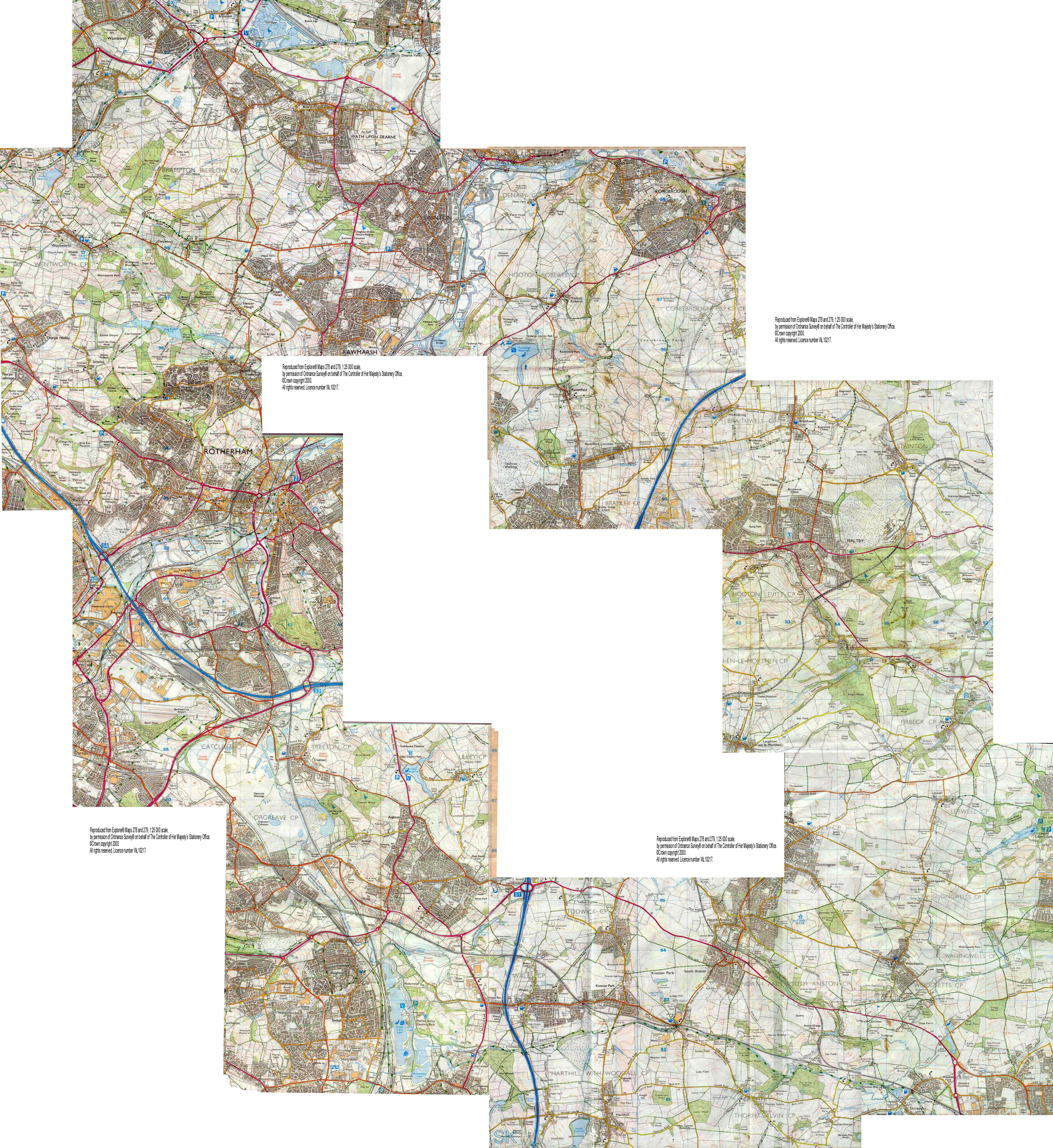
The sequential list provides the 'conventional' 6-figure grid references for use in conjunction with OS Landranger Map 111 or Explorer Maps 278 (Sheffield and Barnsley) and 279 (Doncaster).
See table at end for summary of available GPS formats.
Google Earth file - this is a large (1Mbyte) file
GPS waypoint file in Garmin format using the GPSU format, generally compatible with PCX5 software (see below). (the PCX5 format is obsolete, not reliably revised for 2018 as GPSU does not now offer the PCX5 format for saving files) and Garmin waypoint file is not now offered, so dropped as a format. Contact me if you want this format.
The format of the Route file was adjusted for my old Garmin GPS12 with PCX5 software. My new GPSMAP 60SCx is does not require the precise format of PCX5 so I now use GPS Utility. Other more conventional formats for the title - with spaces or underscores, or a leading hyphen - are ineffective. Load the route file first, then the waypoint file, as the route file loads the waypoints but without the symbol specification. (Alternative PCX5 format file with waypoint, routes and track is obsolete)
These files are loadable to newer Garmins (that can't
use PCX5), Magellan and other GPS brands using inter
alia
GPS Utility,
a shareware product written by Alan
Murphy. (Following
Alan's retirement, GPS Utility (GPSU) no longer requires users to register the
software. GPS Utility is now provided as fully functional Freeware which
does not require registration).
IF you have certain Garmin devices, you can
load the track/waypoint files directly to your device using Garmin Connect.
Alternatively, there is the free (to Garmin
users) BaseCamp software. Follow this
link (under development). There is
likely to be similar free software appropriate to other brands.
GPSU files: If you have GPSU (even if you don't have a GPS unit) you can download a map and display the route. Download one of the following set files into the same folder, open GPSU and select the first (.txt) file.
1:50000 scale: GPSU waypoint file map
calibration
1:25000 scale: track, waypoints and route GPSU
waypoint file
(.txt), OS Explorer map file and calibration
file
The main file is the same in each case; in GPSU, 'View' Tab, Calibrations and
select RRR_OS.png for 1:50k, RRR_ac1.jpg for 1:25k
Note, the map files are 0.13 and 8 Mbytes (1:50 and 1:25 respectively). Click on the 'map' icon and you should have the route displayed in front of you. The Start STA is the waypoint to the SE of the northmost waypoint A05. Alternatively, the resulting map is (planned to be) available as an acrobat file. You can then transfer the information to your own copy of the map; these versions are probably inadequate for navigation. The map is reproduced from Landranger Map 111 Sheffield and Doncaster, 1:50000 scale ©Crown copyright 1974-2002. or Explorer® Maps 278 and 279, 1:25000 scale, by permission of Ordnance Survey® on behalf of The Controller of Her Majesty’s Stationery Office. ©Crown copyright 2000. All rights reserved. Licence number WL10217.
Waypoints only in .csv format for
you to process (with Excel, for example) as you will! Shows 6 and 10
figure grid ref data.
Garmin POI: POI (Point Of Interest)
is a .csv format, in
sequence (co-ordinates are lat/long). To load Point of
Information (aka waypoints to a Garmin device) you can use the
Garmin POI file
If you have not installed POI Loader, go to the
Garmin
download page which has installation instructions. Basically you connect
your device to the USB port, open the loader, connect the device to it and then
select the POI file. It should load direct to your device - waypoints only, not
the track (use BaseCamp or GPSU to transfer both).
Others may find these useful to create Memory Map and Anquet
map route files
Memory Map route files . The 2019 route with waypoint names is NOT CURRENTLY available from RoundRotherham_mmo.mmo, in a form that can be used directly (use it to replace file userdata-Memory-Map-OS-5.mmo or import to the PC version). Waypoint, Track and Route versions are available in MapTech Terrain format, which can be imported into Memory Map. See separate section on using a Sat Nav with Memory Map.
GPS waypoints in .arf format for Anquet maps. GPSU refused to save in .aef format.
The file, created by GPSU, is said to contains the waypoints and routes as Anquet paths. Or
(not updated, contact me if you want this format) as a single
Anquet route
(created by GPSU - hope it works. Or as a
series of paths derived from each stage (only stage 1
- 2007 -
at present for test purposes). Unfortunately, I have not been able to check
whether Anquet reads the files properly.
Courses for Garmin Forerunner. Right click on link and Save As Target... Make sure (a) you remember where you saved it and (b) you have the latest version of Training Center – there was a major upgrade recently (2011). Then import the Course file into Training Center select File /'Import to Current user account' / Courses, and from the drop down menu at the bottom of the dialogue box select Garmin Courses .crs Browse to find the file you downloaded, and import it. You should get a page showing Courses on the left, and on clicking the + see Stages 1 to 8 (or Tracks 1a to 8). Click on each in turn to see the course on the display. In Training Center, File / Click on Send To Device (obviously with the device plugged in!) for each stage. You want to Sent Courses to the device, preferably selecting just the Round Rotherham sections. Select the 8 sections (The Send to Device icon is next to the Download History icon, the first 2 on the task bar), assuming you downloaded the .crs file. This file has the course, not the waypoints (you will have a breadcrumb to follow on your forerunner - I trust). I believe that's what's meant to happen, and it has been reported to have worked. Alternative version as a single track rather than split into stages (by request) - not updated for 2019, contact me if you require this format.
Alternative formats for Forerunner .tcx .hst Warning - if you use either of these formats, back up the history on Training Center first. They could overwrite your existing data on Training Center. These have not worked for me, though and are big files (500 kbytes).
Having loaded the .crs (forerunner) RRR route into Garmin Training Center, I am perplexed to see the trace displaced 100 m ESE – a datum problem I guess; WGS84 v. OS nat grid and others. This difference may also apply for other formats. I will be investigating this (not for the first time).
GPX file: The standard format .gpx file or without the route .gpx-rte (should be compatible with any good GPS software)
The next section is a bit experimental, not fully tested. If shared file is not for the current year, download the 'GPX with one continuous track' file (see table below) and Import Activity
A problem has been reported that a Garmin device (a Fenix) would only import
the track for the first stage, not all stages. For such devices, the procedure
is as follows:
Download GPX with continuous track and at
the top right (uparrow into cloud icon) select Import Activity to incorporate
this file. ALternatively,
download shared file from Garmin
Connect (2023
version).
Note: if you select a 'Nearby Course' for Round Rotherham (etc) it could be
someone's route for
an earlier year, with their errors (if they went wrong anywhere) - not ideal - and not up-dated
with this years changes. This
link is to
the route for the current year (well, 2023 at present) using the 1st Sept update.
Alternatively, upload GPX file to Garmin Connect (Training - Courses - Import (at bottom right
of pop-up box), and follow prompts - edit title, etc)
You may be able to download this course
Round Rotherham
2023
To get it onto your device, connect your device to the computer, open Garmin
Connect and click
Send to Device, follow prompts - a pop-up box should appear, select device
you want to send course to, click Send Now. Then Select Application - Garmin
Express - Open Link Garmin Express should then do the upload (Sync)
On your Fenix, press top right button and select the Activity, e.g. Trail
Running. Press Menu (middle on left), scroll down to Navigation and select it
(top right). Scroll down to Courses, select. You will get your list of courses -
maybe only RR2023. If so, select it (or scroll through list of courses to RR2023
and select). Select Do Course.
If you get a warning message of too many points when loading to your device,
there are alternative files in which the track is split into 2 parts,
Start to CP4 (Woodsetts) and from
CP4 to the finish At Woodsetts, you
have to Menu - Navigation - Stop Course and then select the second part.
Other:
Garmin Mapsource format .gdb,
or without the route .gdb-rte or transfer to
and from Garmin units with computer connectivity (except Forerunner, I believe)
Download 3 files (right click on link, Save Target As...) to the same folder
the
GPSU file (.txt), an OS Explorer map file and a calibration
file.
Open GPS Utility, File Open the rrr_gps_map_txt.txt file.
The .jpg file is reproduced from Explorer® Maps 278 and 279, 1:25 000 scale,
by permission of Ordnance Survey® on behalf of The Controller of Her Majesty’s Stationery Office.
©Crown copyright 2000.
All rights reserved. Licence number WL10217/100047659
View - Calibrations - select the map file rrr25_ac1.jpg
It should automatically calibrate using the rrr25_ac1.gux file
Set your GPS for OSGB grid and Ord Survey datum - if the route file works with your GPS, you should only need that - it will give the 170 waypoints in 9 packets of up to 30 waypoints (2 packets for Stage 1), starting and finishing at a checkpoint. All sections are within the 30 waypoint limit of the GPS12.
Sequential list of 10-figure
Grid References for the 170+ critical points (generally changes
of direction)
The file lists the waypoints round the route, with 10 figure grid references
(usually only use the first 3 in each set of 5). The route goes from Start (STA)
through locations of Stage 1 (A01-A30) to Checkpoint 1 (CP1). Then Stage 2
(B01-B24) to CP2, etc, etc to the Finish (FIN). The description indicates the
direction to take when following the route.
6-figure Grid References for the Checkpoints
To clear your GPS of Round Rotherham waypoints, use the Clear data set. Each year there are changes, so it is best to get a clean start. Also, you may want to load other waypoints, e.g. the Munros, before your next run. Delete waypoints with the selected symbols of Flag (routine waypoints), Circle-X (checkpoints) and First Aid (tricky locations). For 2011, symbol is Flag (aka Golf Course), or delete waypoints starting R-
If you require a different GPS data format, contact me, rrrhenry-at-hmarston.co.uk (include a Subject and Body text - unexplained attachments may be treated as spam), and I will try to generate it for you (using GPSU).
GPS data files available
Most of the files listed above give the waypoints (around 160 locations where there is a change in direction, plus the checkpoints), the route (straight lines linking the waypoints, indicating general direction to go) and the track (the route I actually followed, points at around 18 s intervals, following twists and turns). These files are listed in column 2, after the description. Column 3 excludes the routes, i.e. waypoints and track. Column 4 is for waypoints only, Column 5 track only
Most GPS files have been updated for 2023 to show route/CP change, with the exception of formats no longer supported by GPSU. Because of the number of alternative versions, check (a) that the creation date of the file is 2023, (b) the file is as you require (some file types correspond to different formats). Contact me, rrrhenry-at-hmarston.co.uk , if the file is not as expected.
Contact me if you have problems with tracks of over 500 points on Stage 1.
| Waypoints, route and track | Waypoints and track | Waypoints | Track only | |
| GPSU (the original file from which others are derived | GPSU file | GPSU txt | ||
| GPX, the usual GPS interchange file (split track) This may not load correctly | gpx | |||
| GPX with one continuous track (see above, GPX section) Or in 2 parts, 1 and 2, if you get a warning message of too many points when loading to your device |
gpx file | one_gpx 1one_gpx 2one_gpx |
||
| PCX5, older GPS interchange file - contact me if you want this format | obsolete | obsolete | ||
| Garmin MapSource file | .gdb | .gdb | ||
| Google Earth | Google Earth file (.kml) | Google earth kml | ||
| Memory Map files |
RoundRotherham_mmo.mmo (old route), mmo not
now offered Route .rxf |
Waypoint, mxf | Track, txf | |
| Anquet files | waypts and 8 routes Single route (arf) | |||
| Garmin Forerunner files | Garmin Forerunner 8 stages.
crs Alternative in one track .tcx .hst |
|||
| Waypoints as Points of Interest (lat/long) | POI | |||
| Waypoints only in .csv format (read into Excel) (OS grid references) | Waypoints in .csv format | |||
| Waypoints only in a simple list | Sequential list | |||
| Checkpoints only in a simple list | Checkpoints |
To accommodate restrictions in name length and numbers of points on a route or track, the sections of the route and track are broken into stages, named either Stage 1, Stage 2, ... or Leg 1, Leg 2, ... etc For the Route files, the long first stage is split into Stage 1A arestnd Stage 1B
Basic GPSU .txt file, which can be used to create alternative formats (NOT for loading directly to devices) using the GPSU software
All other files are GPX files, the de facto standard
GPX file with Waypoints, Route and Track
GPX file with Waypoints and Track (full route)
Stage 1 GPX file with Waypoints and Track
Stage 2 GPX file with Waypoints and Track
Stage 3 GPX file with Waypoints and Track
Stage 4 GPX file with Waypoints and Track
Stage 5 GPX file with Waypoints and Track
Stage 6 GPX file with Waypoints and Track
Stage 7 GPX file with Waypoints and Track
Stage 8 GPX file with Waypoints and Track
Last update 24 October, 2023 by
rrrhenry-at-hmarston.co.uk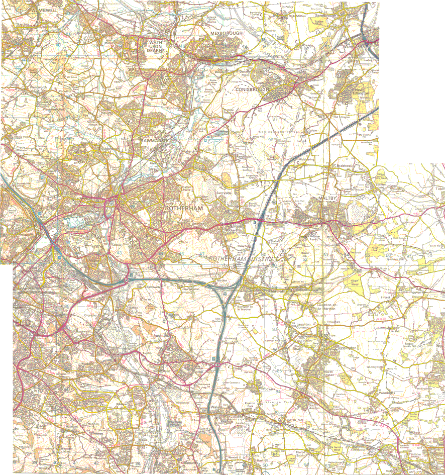